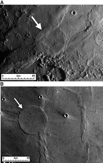
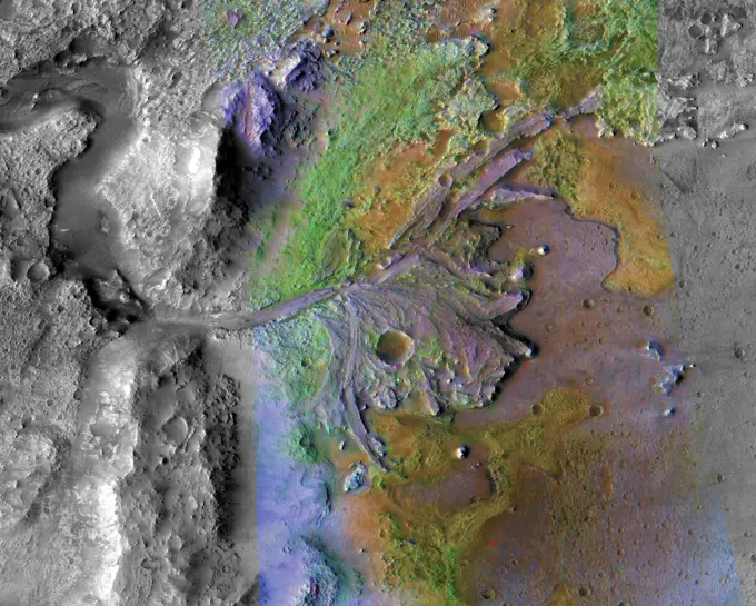
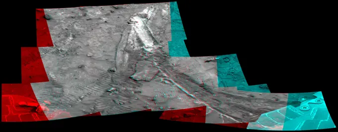
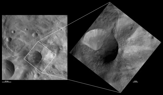
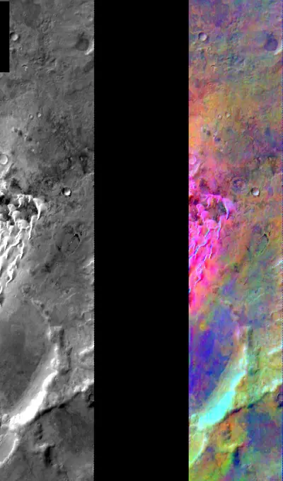
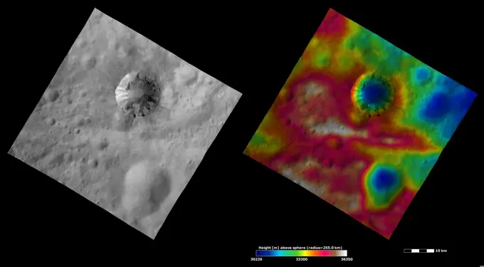
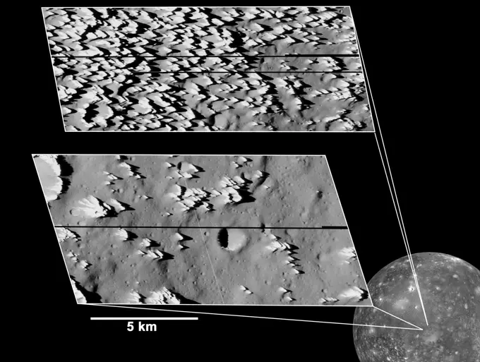
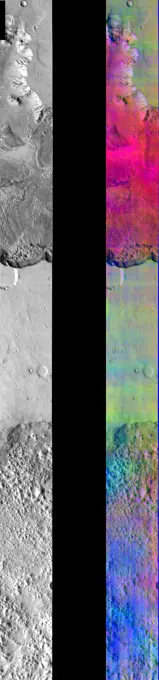
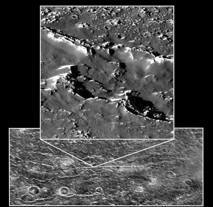
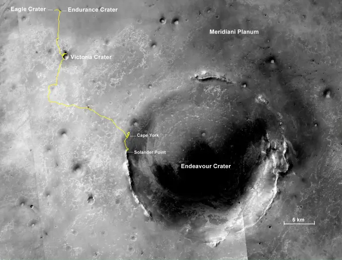
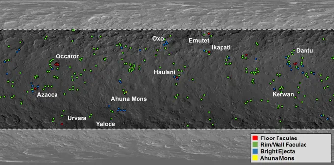
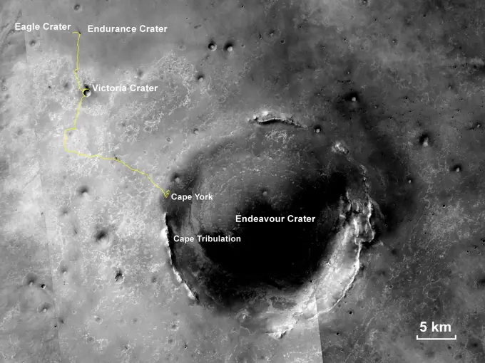
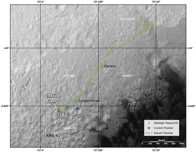
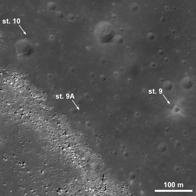
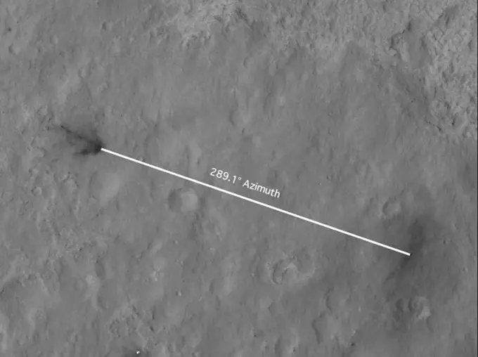
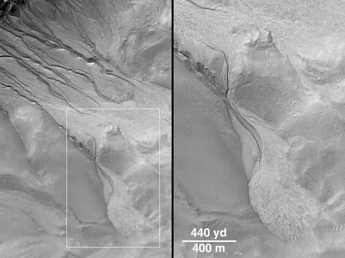
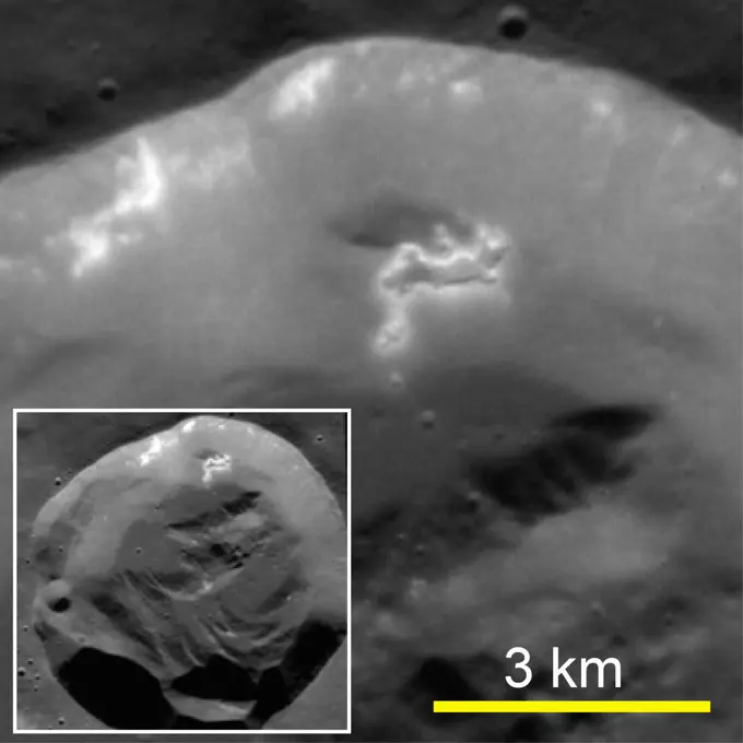
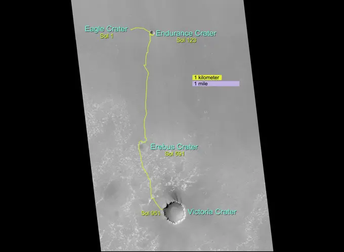
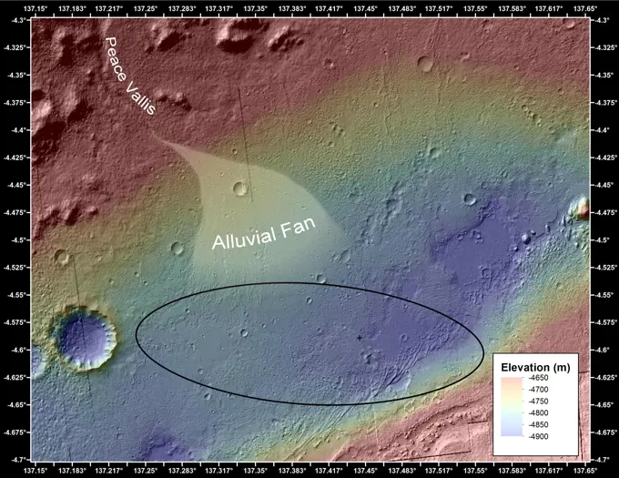
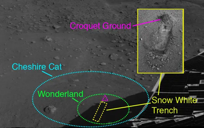
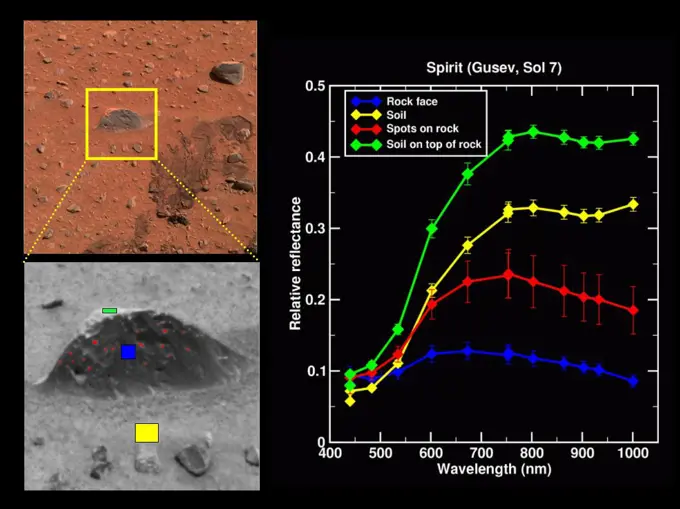
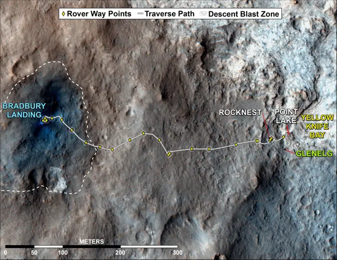
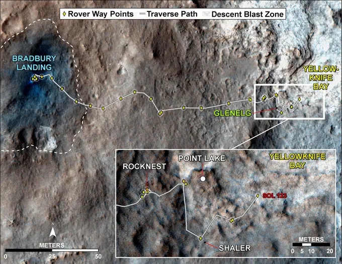
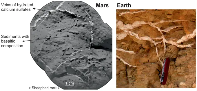
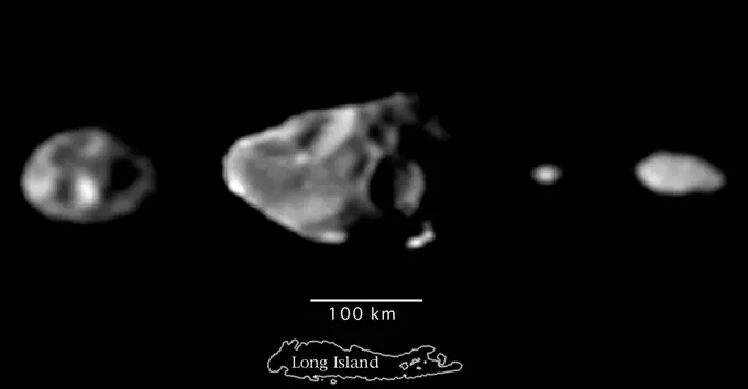
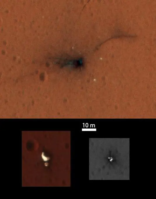
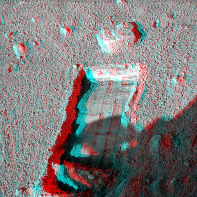
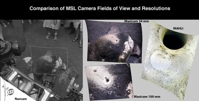
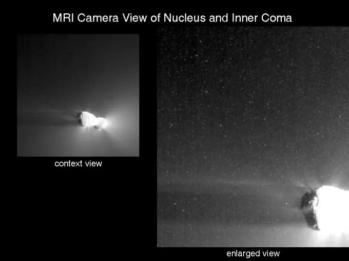
Fine ArtVintageFootageSubscriptionBoardsFree ResearchPricing
  • Fine Art
  • Vintage
  • Footage
  • Subscription
  • Boards
  • Free Research
  • Pricing

Mars and Vesta Geological Features

Images of Mars and Vesta showcasing geological formations, channels, and craters. Features include mineral alterations and detailed terrain maps.

Proposed Mars Polar Lander Landing Site (Flat Map)

Assets in this Story

6145-44497235
Proposed Mars Polar Lander Landing Site (Flat Map)
6145-45026096
On ancient Mars, water carved channels and transported sediments to form fans and deltas within lake basins. Spectral data acquired by NASA's Mars Reconnaissance Orbiter, indicate chemical alteration by water.
6145-44899806
These images from NASA's Dawn spacecraft are located in Vesta's Numisia quadrangle, in Vesta's northern hemisphere.
6145-45040392
These images from NASA's Dawn spacecraft show Tuccia crater, after which Tuccia quadrangle is named. Tuccia crater is located about 40 kilometers (25 miles) northward of the rim of Vesta's large south polar Rheasilvia basin.
6145-44714173
Wrinkle-Ridge Rings on Mercury and Mars
6145-45266161
This image is of Jezero Crater on Mars, the landing site for NASA's Mars 2020 mission. It was taken by instruments on NASA's Mars Reconnaissance Orbiter (MRO), which regularly takes images of potential landing sites for future missions. On ancient Mars, water carved channels and transported sediments to form fans and deltas within lake basins. Examination of spectral data acquired from orbit show that some of these sediments have minerals that indicate chemical alteration by water. Here in Jezero Crater delta, sediments contain clays and carbonates.
6145-44747758
NASAs Mars Exploration Rover Spirit acquired this mosaic on May 21, 2007, while investigating the area east of the elevated plateau known as 'Home Plate' in the 'Columbia Hills.' 3D glasses are necessary to view this image.
6145-44900317
These images from NASA's Dawn spacecraft are located in asteroid Vesta's Tuccia quadrangle, in Vesta's southern hemisphere.
6145-44619899
Kaiser Crater DCS
6145-44917761
MLA Reflectivity near the North Pole
6145-44609135
Covered Ground
6145-45044166
These images taken by NASA's Dawn framing camera are located in asteroids Vesta's Numisia quadrangle.
6145-44528912
Callisto Close-up with Jagged Hills
6145-44619669
Canyon in DCS Color
6145-44559164
Callisto Crater Chain at High Resolution Shown in Context
6145-44984371
The gold line on this image shows NASA's Mars Exploration Rover Opportunity's route as it investigating on the western rim of Endeavour Crater.
6145-45080055
This image of comet 67P/Churyumov-Gerasimenko marks the first touchdown point of the Philae lander of the European Space Agency's Rosetta mission. The image was taken by on Sept. 14, 2104, nearly two months before Philae's Nov. 12 landing.
6145-44881296
This mosaic depicts a portion of asteroid Vesta imaged by NASA's Dawn spacecraft where pockets of bright materials are visible.
6145-44620436
Melas Chasma in IR Color
6145-58958751
Rima Bradley
6145-44846852
This pair of images shows the area affected by the impactor released by NASA's Deep Impact spacecraft in July 2005.
6145-58967702
These images from NASA's Dawn spacecraft show Claudia crater (marked by an arrow) and its surroundings. Claudia crater is the crater which is used to define 0 longitude on asteroid Vesta.
6145-44893548
These images from NASA's Dawn spacecraft are located in asteroid Vesta's Numisia quadrangle, in Vesta's southern hemisphere.
6145-45022609
These images from NASA's Dawn spacecraft show part of asteroid Vesta's equatorial region, which contains impact craters and troughs (linear depressions).
6145-44590272
This anaglyph of Mexico's Yucatan Peninsula was generated from NASA's Shuttle Radar Topography Mission data, and shows a subtle but distinctive indication of the Chicxulub impact crater. 3D glasses are necessary to view this image.
6145-44572339
This is a three-dimensional view of Isabela, one of the Galapagos Islands located off the western coast of Ecuador, South America.
6145-44964780
NASA's Mars Exploration Rover Opportunity drove onto the 'Cape York' segment of the rim of Endeavour Crater in August 2011 and departed Cape York in May 2013. The location of a rock target called 'Esperance' is indicated in the main map.
6145-45110871
This enhanced color view from NASA's New Horizons spacecraft zooms in on the southeastern portion of Pluto's great ice plains, where at lower right the plains border rugged, dark highlands informally named Krun Macula.
6145-58967208
NASA's Dawn spacecraft obtained this false-color image of asteroid Vesta's equatorial region with its framing camera on July 25, 2011.
6145-45261472
This map from NASA's Dawn mission shows locations of bright material on dwarf planet Ceres. There are more than 300 bright areas, called faculae, on Ceres. Scientists have divided them into four categories bright areas on the floors of crater (red), on the rims or walls of craters (green), in the ejecta blankets of craters (blue), and on the flanks of the mountain Ahuna Mons (yellow).
6145-44918489
These maps of Earth's moon highlight the region where the twin spacecraft of NASA's Gravity Recovery and Interior Laboratory (GRAIL) mission will impact on Dec. 17, marking the end of its successful endeavor to map the moon's gravity.
6145-44890660
This image from NASA's Dawn spacecraft of asteroid Vesta shows Aelia crater, located in Vesta's Lucaria Tholus quadrangle, in Vesta's southern hemisphere.
6145-44866836
Targeted Color Imaging: Degas Crater
6145-44671220
Defrosting of Russell Crater Dunes
6145-44964774
This map shows the route driven by NASA's Opportunity rover from the site of its landing, inside Eagle crater, to its location more than 112 months later, in late May 2013, departing the 'Cape York' section of the rim of Endeavour crater.
6145-44712694
Craters Deformed and Shortened
6145-45002285
This map shows the route that NASA's Curiosity Mars rover drove inside Gale Crater from its landing in August 2013 through Jan. 26, 2004. The rover is approaching a gap between two low scarps, 'Dingo Gap.'
6145-44815729
Retracing the Steps of Apollo 15
6145-44900586
This portion of an image from NASA's Mars Reconnaissance Orbiter has been annotated to show the relative positions between NASA's Curiosity rover (right) and the impact site of its sky crane, or descent stage.
6145-44764939
Details about the newly discovered Rembrandt impact basin were published recently in Science magazine, and the images shown here are from that article.
6145-44565865
Mars Pathfinder First Anniversary Special -- Refined Landing Site Location
6145-44614685
Spirit's Mission From Beginning to End
6145-45072221
This topography map shows a portion of the Gale Crater region on Mars, where NASA's Mars Curiosity rover landed on August 6, 2014. The rover (marked with a star) is currently headed toward 'Pahrump Hills.'
6145-45129735
A 100 foot-wide, 28-million-pound boulder, was found to have moved 460 feet on comet 67P/Churyumov-Gerasimenko in the lead up to perihelion in August 2015, when the comet's activity was at its highest.
6145-44507006
Evidence for Recent Liquid Water on Mars: Channels and Aprons in East Gorgonum Crater
6145-44641238
This stereo anaglyph from NASA's Mars Exploration Rover Spirit shows rocks solidified from lava. Seen here is a group of boulders informally named 'FuYi.' 3D glasses are necessary to view this image.
6145-58967446
In a Slump
6145-44679247
Opportunity's Path, Sol 1,215
6145-44525012
This anaglyph NASA's Shuttle Radar Topography Mission, shows the city of Bhuj, India. 3D glasses are necessary to view this image.
6145-45292724
This image shows two possible routes (blue and purple) to the fan-shaped deposit of sediments known as a delta for NASA's Perseverance rover, which landed at the spot marked with a white dot in Mars' Jezero Crater. The yellow line marks a notional traverse exploring the delta. The base image is from the High Resolution Imaging Experiment (HiRISE) camera aboard NASA's Mars Reconnaissance Orbiter (MRO). MRO's mission is managed by NASA's Jet Propulsion Laboratory, a division of Caltech in Pasadena, California, for NASA's Science Mission Directorate. Lockheed Martin Space in Denver built the spacecraft. The University of Arizona in Tucson provided and operates HiRISE. A key objective for Perseverance's mission on Mars is astrobiology, including the search for signs of ancient microbial life. The rover will characterize the planet's geology and past climate, pave the way for human exploration of the Red Planet, and be the first mission to collect and cache Martian rock and regolith (broken
6145-45009197
This view from NASA's rover Opportunity, of an American flag on metal recovered from the site of the World Trade Center towers shortly after their destruction, was taken on Mars on Sept. 11, 2011, the 10th anniversary of the attacks on the towers.
6145-44701481
Durham, North Carolina, Students Study Martian Volcanism
6145-44767871
This composite image depicts the moon's rugged south polar region in two lights. The color image is the highest resolution topography map to date of the moon's south pole.
6145-44610183
Hole Lotta Grindin' Going On
6145-44707606
Phoenix Lander Work Area
6145-45111092
Comparison of detected methane plumes over Aliso Canyon, California, acquired 11 days apart in Jan. 2016 by NASA's AVIRIS and Hyperion instruments on NASA satellites in low-Earth orbit.
6145-44572283
Large Impact Structures on Europa
6145-44507004
The first clue that there might be places on Mars where liquid groundwater seeps out onto the surface came from a picture taken by NASA's Mars Global Surveyor. 3D glasses are necessary to identify surface detail.
6145-45262256
This view from NASA's Dawn mission shows Ceres' tallest mountain, Ahuna Mons, 2.5 miles (4 kilometers) high and 11 miles (17 kilometers) wide. This is one of the few sites on Ceres at which a significant amount of sodium carbonate has been found, shown in green and red colors in the lower right image. The top and lower left images were collected by Dawn's framing camera. The top image is a 3D view reconstructed with the help of topography data. A non-annotated version is available at
6145-44609099
Halfway There
6145-44910190
This image shows the topography, with shading added, around the area where NASA's Curiosity rover landed. An alluvial fan, or fan-shaped deposit where debris spreads out downslope, has been highlighted in lighter colors for better viewing.
6145-44709461
Phoenix's Workplace Map
6145-44607921
Magic Carpet Shows Its Colors
6145-44562272
NIMS E4 Observations of Europa Trailing Hemisphere
6145-45050235
This map shows the route driven by NASA's Curiosity Mars in its approach to and April 1, 2014, arrival at a waypoint called 'the Kimberley,' which rover team scientists chose in 2013 as the location for the mission's next major investigations.
6145-44911416
This map shows the route driven by NASA's Mars rover Curiosity through the 56th Martian day, or sol, of the rover's mission on Mars (Oct. 2, 2012).
6145-45266919
This map shows the route driven by NASA's Curiosity Mars rover, from the location where it landed in August 2012 to its location in August 2019, and its planned path to additional geological layers of lower Mount Sharp. The blue star near top center marks Bradbury Landing, the site where Curiosity arrived on Mars on Aug. 5, 2012, PDT (Aug. 6, EDT and Universal Time). Curiosity landed on Aeolis Palus, the plains surrounding Aeolis Mons (Mount Sharp) in Gale Crater. The base image for the map is from the High Resolution Imaging Science Experiment (HiRISE) camera on the Mars Reconnaissance Orbiter. North is up. Bagnold Dunes form a band of dark, wind-blown material at the foot of Mount Sharp. The scale bar at lower right represents one kilometer (0.62 mile).
1746-19663299
These images show a very young lunar crater on the side of the moon that faces away from Earth, as viewed by NASAs Moon Mineralogy Mapper on the Indian Space Research Organizations Chandrayaan-1 spacecraft. On the left is an image showing brightness at shorter infrared wavelengths. On the right, the distribution of water-rich minerals (light blue) is shown around a small crater. Both water- and hydroxyl-rich materials were found to be associated with material ejected from the crater.
6145-44715697
Phoenix's Workspace
6145-44745945
Spreading Ridge Transforms On Enceladus
6145-44917895
This map shows where NASA's Mars rover Curiosity has driven since landing at a site subsequently named 'Bradbury Landing,' and traveling to an overlook position near beside 'Point Lake,' in drives totaling 1,703 feet (519 meters).
6145-44606736
Landing Trail in 3-D
6145-58969616
Water Around a Fresh Crater
6145-44918459
This map traces where NASA's Mars rover Curiosity drove between landing at a site subsequently named 'Bradbury Landing,' and the position reached during the mission's 123rd Martian day, or sol, (Aug. 10, 2012).
6145-44927287
This set of images shows the similarity of sulfate-rich veins seen on Mars by NASA's Curiosity rover to sulfate-rich veins seen on Earth.
6145-44567225
Scale Comparison of the Inner Small Satellites of Jupiter
6145-44636431
Cassini's Visit to Dione
6145-45096445
This color-coded map from NASA's Dawn mission shows the highs and lows of topography on the surface of dwarf planet Ceres. It is labeled with names of features approved by the International Astronomical Union.
6145-44927284
This image maps the traverse of NASA's Mars rover Curiosity from 'Bradbury Landing' to 'Yellowknife Bay,' with an inset documenting a change in the ground's thermal properties with arrival at a different type of terrain.
6145-44628246
Enceladus First Flyby
6145-45120740
On Nov. 1, 2016, the High Resolution Imaging Science Experiment (HiRISE) camera on NASA's Mars Reconnaissance Orbiter observed the impact site of Europe's Schiaparelli test lander, gaining the first color view of the site since the lander's Oct. 19, arriv
6145-44727119
The robotic arm on NASA's Phoenix Mars Lander enlarged a trench beside a rock called 'Headless' on Sept. 20, 2008 in preparation for sliding the rock into the trench. 3D glasses are necessary to view this image.
6145-44562028
Europa 6th Orbit NIMS Data
6145-44665744
This global digital map of Saturn's moon Mimas was created using data taken by the Cassini spacecraft, with gaps in coverage filled in by NASA's Voyager spacecraft data
6145-58959284
This image shows the surface of comet Tempel 1 before and after NASA's Deep Impact mission sent a probe into the comet in 2005. The region was imaged by Deep Impact before the collision (left), then six years later on by NASA's Stardust-NExT mission.
6145-44494358
During its flight and lunar orbit, NASAs Clementine spacecraft returned images of the planet Earth and the Moon.
6145-44592362
Spring Defrosting of Mass-Movement Material at South High Latitudes
6145-44637430
Cassini's Oct. 28, 2005, Titan Flyby
6145-44558113
Pyroxene at Syrtis Major
6145-45100009
This map shows the route driven by NASA's Curiosity Mars rover from the location where it landed in August 2012 to its location in mid-November 2015, approaching examples of dunes in the 'Bagnold Dunes' dune field.
6145-44613068
Spirit's Extended-Mission Destination
6145-44899259
This set of images compares test images taken by four cameras on NASA's Curiosity rover at NASA's Jet Propulsion Laboratory before launch.
6145-44839539
NASA's EPOXI mission spacecraft obtained these views of the icy particle cloud around comet Hartley 2. The image on the left is the full image of comet Hartley 2 for context, and the image on the right was enlarged and cropped.
2401 S. Ervay, Suite 206
Dallas, Texas 75215
United States
Get Started
My BoardsFree ResearchMy Cart
For Creators
How To License Your ContentSuperStock For StudentsFrame of MindContributor PortalNew Image Picks From Our Editors
Resources
LicensingTerms & ConditionsAbout UsAPI AccessPricingPrivacy
Contact
+1 866 236 0087help@superstock.com Contact form
©2026 SuperStock. All Rights Reserved. -A
This site is protected by reCAPTCHA and Google Privacy Policy and Terms of Service apply.