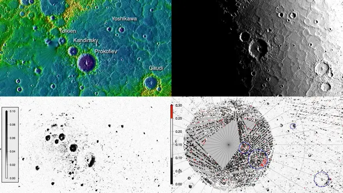
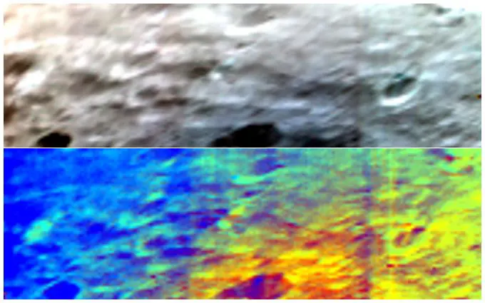
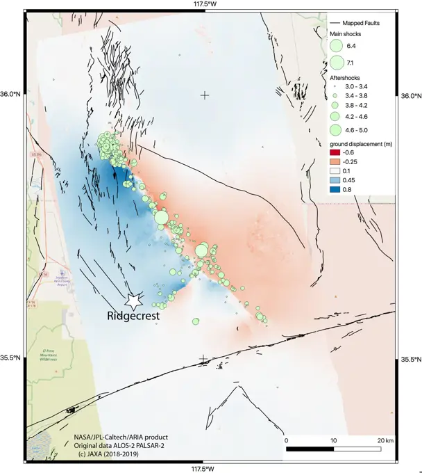
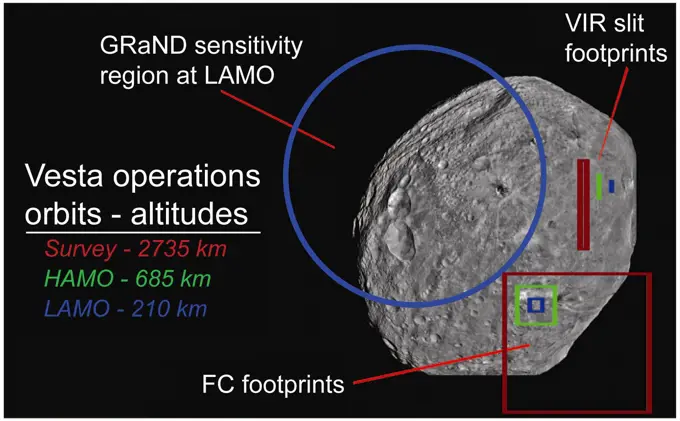
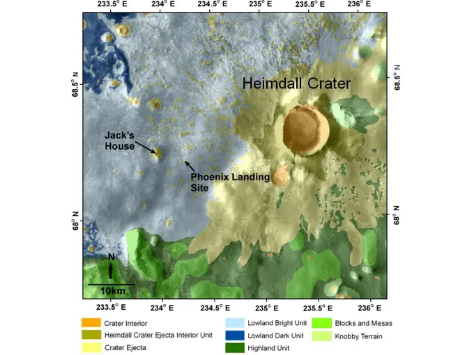
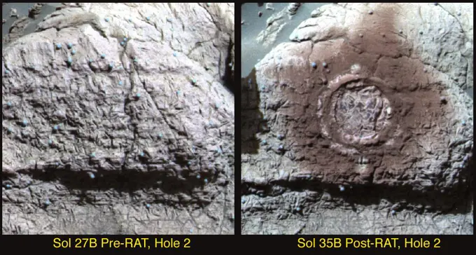
Asteroid Vesta Imagery

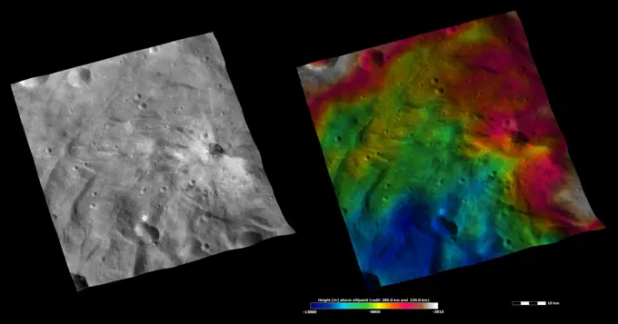
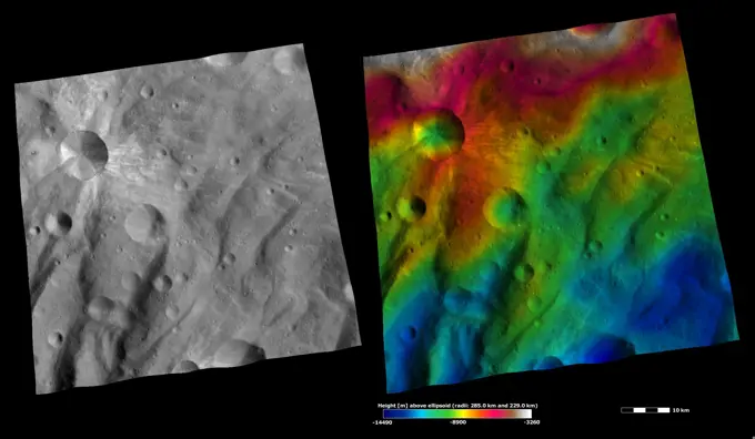
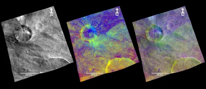
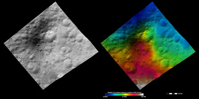
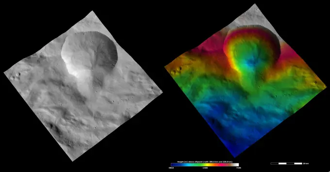
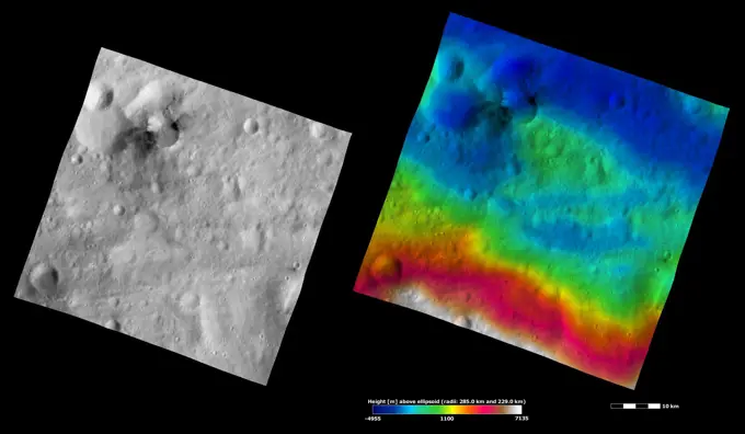
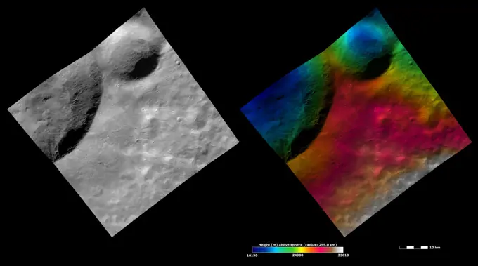
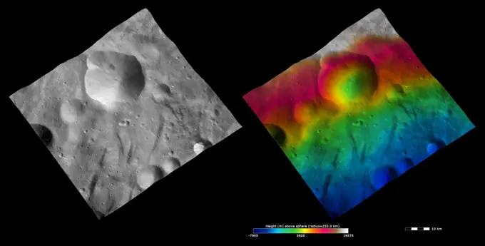
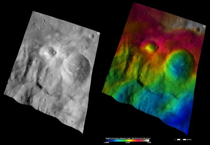
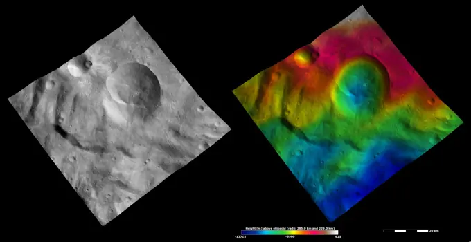
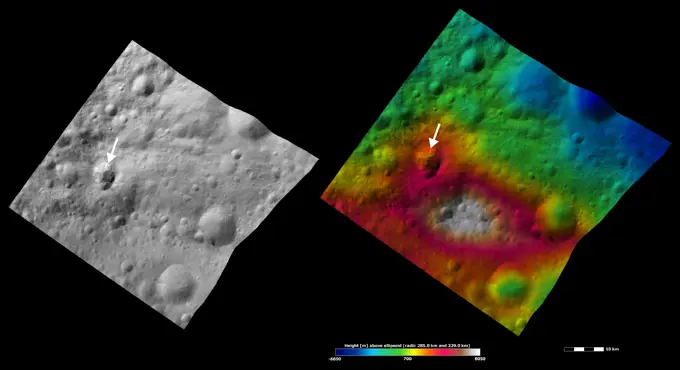
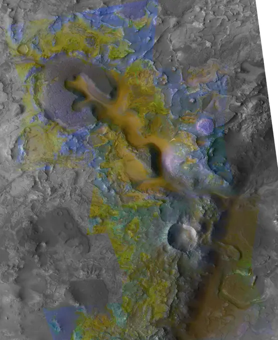
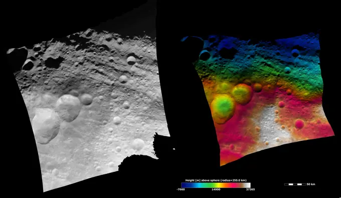
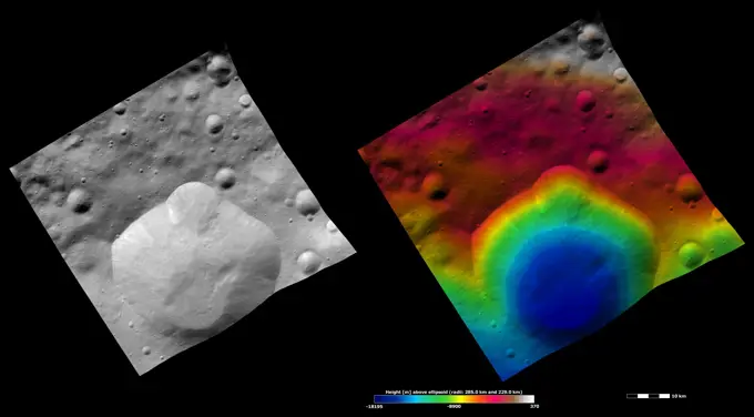
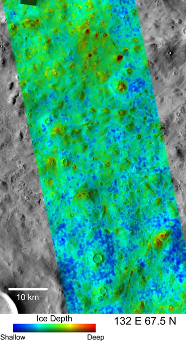
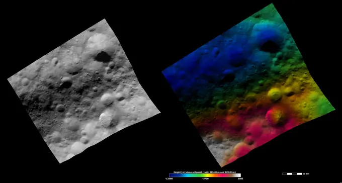
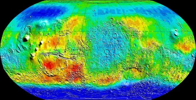
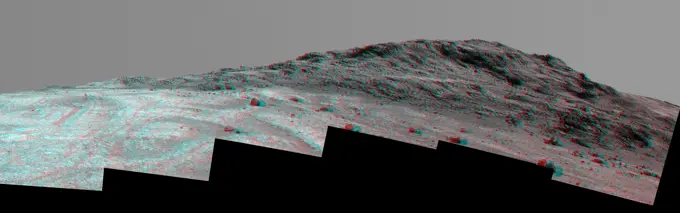
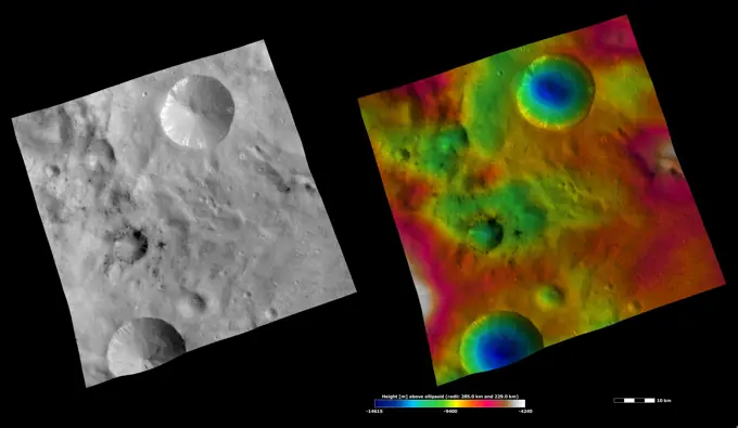
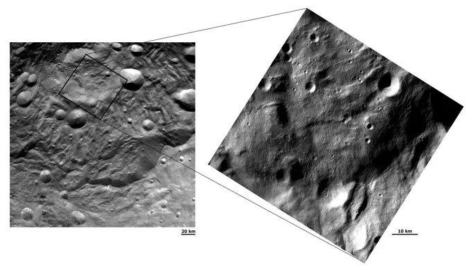
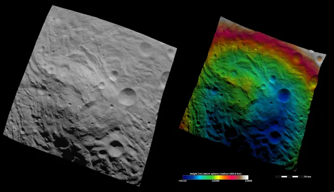
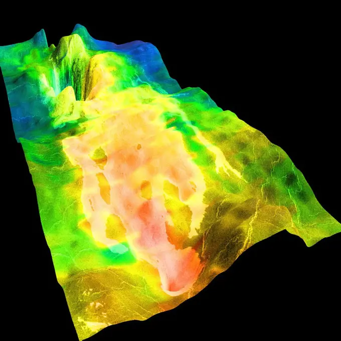
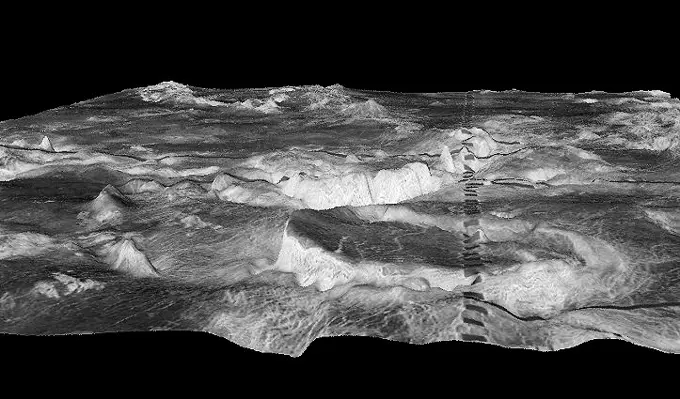
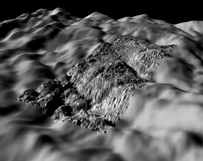
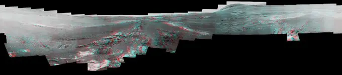
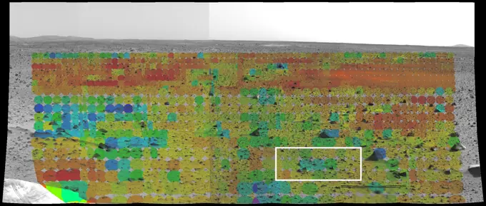
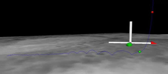
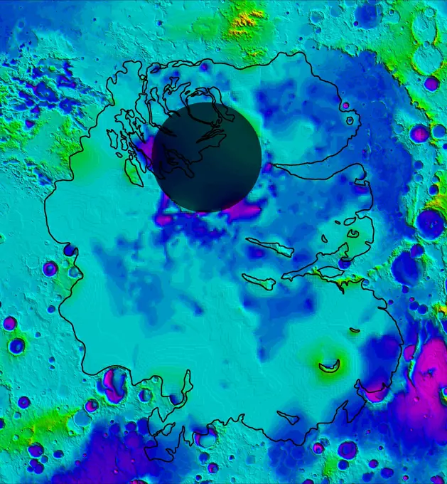
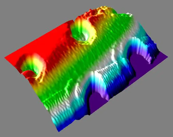
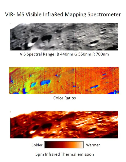
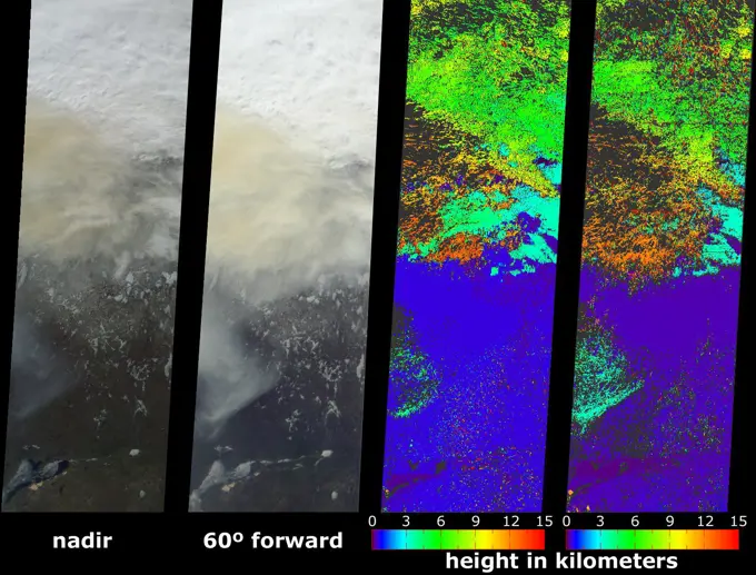
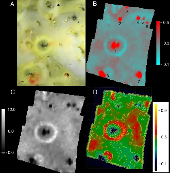
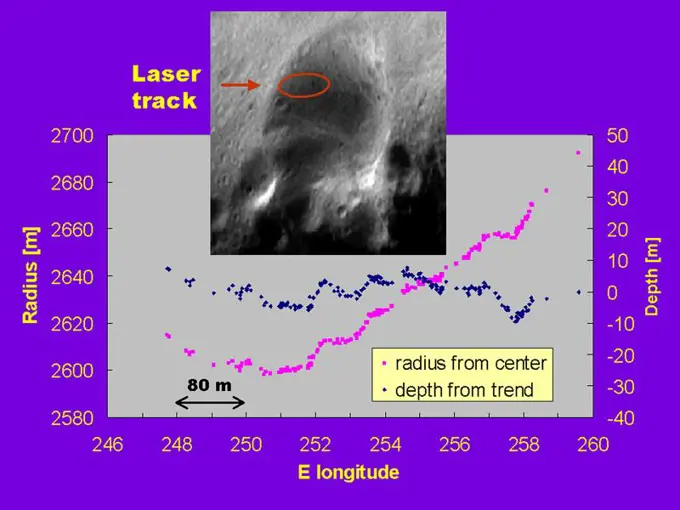
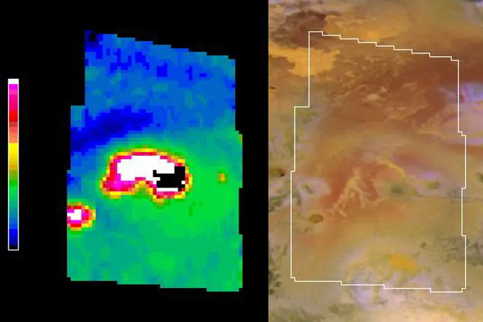
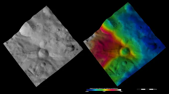
Diverse images from NASA's Dawn spacecraft showcasing the terrain and surface details of asteroid Vesta, including color variations and geological features.

These images from NASA's Dawn spacecraft are located in asteroid Vesta's Sextilia quadrangle, in Vesta's southern hemisphere.

Assets in this Story

6145-44894699
These images from NASA's Dawn spacecraft are located in asteroid Vesta's Urbinia quadrangle, in Vesta's southern hemisphere.
6145-44892810
These images from NASA's Dawn spacecraft are located in asteroid Vesta's Urbinia quadrangle, in asteroid Vesta's southern hemisphere.
6145-44886310
These composite images from NASA's Dawn spacecraft show three views of a terrain with ridges and grooves near Aquilia crater in the southern hemisphere of the giant asteroid Vesta.
6145-45044129
These images from NASA's Dawn spacecraft show the brightness/darkness of asteroid Vesta's surface. These images are located in Vesta's Marcia quadrangle.
6145-44894998
These images from NASA's Dawn spacecraft are located in asteroid Vesta's Sextilia quadrangle, in Vesta's southern hemisphere.
6145-44890705
NASA's Dawn spacecraft of asteroid Vesta shows the apparent brightness of asteroid Vesta's surface. Aquilia crater, located in Vesta's Pinaria quadrangle, is the large crater that dominates the top part of both images.
6145-44897124
These apparent brightness and topography images from NASA's Dawn spacecraft are located in asteroid Vesta's Gegania quadrangle, in Vesta's southern hemisphere.
6145-44880536
Located in the Marcia quadrangle, the left-hand image from NASA's Dawn spacecraft shows the apparent brightness of asteroid Vesta's surface. The right-hand image is based on this apparent brightness image.
6145-45038581
These images from NASA's Dawn spacecraft show Urbinia crater on asteroid Vesta. Urbinia crater is distinctive because is has an irregularly shaped rim due to the formation of other impact craters along its rim and then subsequent erosion.
6145-44886311
These composite images from NASA's Dawn spacecraft show three views of a terrain with ridges and grooves near Aquilia crater in the southern hemisphere of the giant asteroid Vesta.
6145-44894427
These images from NASA's Dawn spacecraft are located in asteroid Vesta's Tuccia quadrangle, in Vesta's southern hemisphere.
6145-44894412
These images from NASA's Dawn spacecraft are located in asteroid Vesta's Tuccia quadrangle, in Vesta's southern hemisphere.
6145-44895246
These images from NASA's Dawn spacecraft are located in asteroid Vesta's Numisia quadrangle, a few degrees below Vesta's equator.
6145-44746220
The color coding on this CRISM composite image of an area on Mars is based on infrared spectral information interpreted as evidence of various minerals present. Carbonate, which is indicative of a wet and non-acidic history, occurs in very small patches.
6145-45065416
A Martian target rock called 'Nova,' shown here, displayed an increasing concentration of aluminum as a series of laser shots from NASA's Curiosity Mars rover penetrated through dust on the rock's surface.
6145-44659475
CRISM's First 'Targeted' Observation of Mars
6145-44702003
Livonia, New York, Students Study Past Martian Water
6145-45020665
NASA's Dawn spacecraft shows the area surrounding the 'snowman craters' in asteroid Vesta's northern hemisphere.
6145-44897342
These apparent brightness and topography images from NASA's Dawn spacecraft are located in asteroid Vesta's Floronia quadrangle, in Vesta's northern hemisphere.
6145-44674321
Depth-to-Ice Map of an Arctic Site on Mars
6145-44894447
These images from NASA's Dawn spacecraft are located in asteroid Vesta's Numisia quadrangle, in Vesta's northern hemisphere.
6145-44807098
Two different instruments on NASA's Cassini spacecraft combined their observations to create a more detailed portrait of the Hotei Regio area on Saturn's moon Titan. Blue lines on top show the location of channels that stand out in the bottom of image.
6145-44576976
NASA Mars Odyssey observations are used in this global view of Mars in intermediate-energy, or epithermal, neutrons. Soil enriched by hydrogen is indicated by the deep blue colors on the map, which show a low intensity of epithermal neutrons.
6145-45098715
This 3-D stereo view from NASA's Mars rover Opportunity shows contrasting textures and colors of 'Hinners Point,' at the northern edge of 'Marathon Valley,' and swirling reddish zones on the valley floor to the left.
6145-44894938
These images from NASA's Dawn spacecraft are located in asteroid Vesta's Sextilia quadrangle, in Vesta's southern hemisphere.
6145-45110616
This image montage features a two-dimensional radar cross section of Mars' north polar cap collected by SHARAD instrument on NASA's Mars Reconnaissance Orbiter spacecraft (top), and a color image mosaic of the polar cap from NASA's Viking project (bottom)
6145-44638828
Titan's Surface
6145-45015676
NASA's Dawn spacecraft obtained these images with its framing camera on Aug.17 and Sept.17, 2011. The left hand image shows scarps, mostly near the bottom. The right hand image is a close up, higher resolution view of a large part of the raised mound.
6145-44528948
Topographic data provided by NASA's Shuttle Radar Topography Mission can provide many clues to geologic history and processes.
6145-44615759
Vigorous vegetation growth in the Southern United States after heavy rains fell during April and early May, 2004, is quantified in these images and data products from NASA's Terra spacecraft.
6145-44888358
This image from NASA's Dawn mission shows the varied minerals on the surface of the giant asteroid Vesta in false color.
6145-45021531
NASA's Dawn spacecraft shows the central area of the south polar basin. The mountain-central complex is the roughly circular feature in the center of the image.
6145-44502171
This topographic image acquired in February 2000 by NASA's Shuttle Radar Topography Mission (SRTM) shows an area south of the Sao Francisco River in Brazil.
6145-44571215
The San Andreas Fault and a Strike-slip Fault on Europa
6145-44574374
This is a three-dimensional perspective view of Saline Valley, about 30 km (19 miles) east of the town of Independence, California created by combining two spaceborne radar images using a technique known as interferometry.
1746-19664709
This perspective view of Venus, generated by computer from Magellan data and color-coded with emissivity, shows the impact crater Markham, named after the English aviator Beryl Markham (the crater was briefly known unofficially as Franklin; the earlier name was not approved by the Nomenclature Committee of the International Astronomical Union). Markham, with a diameter of 71 km, is one of more than 400 Venusian craters whose formation triggered the outflow of highly fluid materials. .
6145-44564366
The view from NASA's Magellan spacecraft shows most of Galindo (V-40) quadrangle looking east; Atete Corona, in the foreground, is a 600-km-long and about 450-km-wide, circular volcano-tectonic feature.
6145-44701475
South Polar Terrains of Enceladus - Highest Resolution View
6145-45265164
This image is a shortened version of a 360-degree panorama taken by the Opportunity rover's Panoramic Camera (Pancam) from May 13 through June 10, 2018, or sols (Martian days) 5,084 through 5,111. This is the last panorama Opportunity acquired before the solar-powered rover succumbed to a global Martian dust storm on the same June 10. The panorama appears in 3D when seen through blue-red glasses with the red lens on the left. To the right of center and near the top of the frame, the rim of Endeavour Crater rises in the distance. Just to the left of that, rover tracks begin their descent from over the horizon towards the location that would become Opportunity's final resting spot in Perseverance Valley, where the panorama was taken. At the bottom, just left of center, is the rocky outcrop Opportunity was investigating with the instruments on its robotic arm. To the right of center and halfway down the of the frame is another rocky outcrop about 23 feet (7 meters) distant from the camera
6145-44840282
Data from NASA's Cassini spacecraft have enabled scientists to make the highest-resolution heat intensity maps yet for the hottest part of a 'tiger stripe' fissure on Saturn's moon Enceladus.
6145-45129990
This map shows footprints of images taken from Mars orbit by the HiRISE camera onbard NASA's Mars Reconnaissance Orbiter as part of advance analysis of the area where NASA's InSight mission will land in 2018.
6145-44645335
First HiRISE Image of Mars: Topographic Model from Photoclinometry
6145-44897128
The area where NASA's Curiosity rover will land on Aug. 5 PDT (Aug. 6 EDT) has a geological diversity that scientists are eager to investigate, as seen in this false-color map based on data from NASA's Mars Odyssey orbiter.
6145-44705959
Six Landing Sites on Mars
6145-44901415
This image shows the landing site of NASA's Curiosity rover and destinations scientists want to investigate. Curiosity landed inside Gale Crater on Mars on Aug. 5 PDT (Aug. 6 EDT) at the green dot, within the Yellowknife quadrangle.
6145-44687761
A global map of Jupiter's moon Io derived from eight images taken by the Long Range Reconnaissance Imager (LORRI) on the New Horizons spacecraft, as it passed Jupiter on its way to Pluto in late February 2007.
6145-44502443
This perspective view acquired by NASA's Shuttle Radar Topography Mission (SRTM) from data collected in the year 2000 shows Patagonia, Argentina, a spectacular landscape formed by volcanoes, rivers, and wind.
6145-45263057
ECOSTRESS acquired this image the night of July 9, 2018, over Egypt. Yellow and red indicate generally higher temperatures. The River Nile is visible as a thin blue line on the main image. The black-and-white inset shows the level of detail available from ECOSTRESS, with the relatively cool Nile River and surrounding vegetation appearing darker.
6145-44733503
Potassium Concentrations on Mars
6145-45097757
Researchers estimating the amount of carbon held in the ground at the largest known carbonate-containing deposit on Mars utilized data including physical properties from THEMIS (left) and mineral information from CRISM (right).
6145-44606515
Mars Through Infrared Eyes of Spirit-3
6145-44746221
Four Types of Deposits From Wet Conditions on Early Mars
6145-44607266
Bouncing Down to Mars
6145-44575166
These L-band images of the Manaus region of Brazil were acquired by NASA's Spaceborne Imaging Radar-C and X-band Synthetic Aperture Radar (SIR-C/X-SAR) aboard the space shuttle Endeavour.
6145-44670251
This map shows the topography of the south polar region of Mars, including topography buried by thick deposits of icy material
6145-44718932
3-D View of Mars Particle
6145-44527597
Volcanism and erosion are prominently seen in this view of the eastern flank of the Andes Mountains taken by NASA's Shuttle Radar Topography Mission (SRTM).
6145-44729829
Map of Iapetus - May 2008
6145-44665987
Liquid Lakes on Titan
6145-52930587
Curiosity's Quadrant Themes. This map shows all the quadrant themes for NASA's Curiosity Mars rover, which is currently in the Roraima quadrant seen at the bottom. The red oval indicates the landing ellipse where the rover was targeted to touch down in 2012. The yellow-tinted quadrants are areas the rover has driven through since then. Themes are chosen in advance of the rover's arrival in a new quadrant; the rover's path couldn't be planned until after the team knew where it landed. Martian latitude and longitude is provided around the outside of the map. With the Curiosity mission, scientists began using quadrant themes to organize the long lists of unofficial nicknames needed to catalog its observations, whether hills, craters, boulders, rocks, and even tiny features on rock surfaces. Scientist deplete these lists of names quickly - especially with Curiosity, which has used more than 10,000 names over nearly 11 years of exploring Mars. Different science targets all require names - i
6145-44875400
The lower portion of a mountain inside Gale crater on Mars contains layers that may be examined by NASA's Mars Science Laboratory. A landing site in Gale, close to the foot of the mountain, has been selected for the mission.
6145-44952434
Northern Topography
6145-44745951
Active Cryovolcanic Features on Titan
6145-44967836
New QuickMap Feature: 3-D!
6145-45103936
Images from NASA's New Horizons mission suggest that Pluto's largest moon, Charon, once had a subsurface ocean that has long since frozen and expanded, pushing out on the moon's surface.
6145-45086450
This annotated image, taken in 2014, shows where features seen in an observation by NASA's Mars Reconnaissance Orbiter have been interpreted as hardware from the Dec. 25, 2003, arrival at Mars of the United Kingdom's Beagle 2 Lander.
6145-44791922
NASA's Lunar Reconnaissance Orbiter captures high noon at Tranquility Base.
6145-44494067
Polar Stereographic Projection
6145-44792182
A depression called 'Scamander Crater,' dominates the terrain near NASA's Mars Exploration Rover Spirit in this map that emphasizes local topography by removing the regional tilt to the northwest.
6145-44682486
This area was designated 'Region D' in the process of evaluating potential landing sites for NASA's Phoenix Mars Lander. The topographical information is from the Mars Orbiter Laser Altimeter on NASA's Mars Global Surveyor orbiter.
6145-45252818
NASA's Mars Exploration Rover Spirit drove a total of 4,143 meters (2.57 miles) between its landing in January 2004 and its 404th martian day, or sol (Feb. 20, 2005). This map on an image taken by the Mars Orbiter Camera on NASA's Mars Global Surveyor shows the course the rover drove during that time. The rover has recently been approaching a ridge overlooking Tennessee Valley on the north flank of Husband Hill. http //photojournal.jpl.nasa.gov/catalog/PIA07393
6145-44494068
Elevations Within the Floor of the Valles Marineris
6145-44718928
Images from Phoenix's MECA Instruments
6145-44659700
Opportunity Traverse Map, 'Eagle' to 'Victoria'
6145-44564596
This perspective view of Venus, generated by computer from NASA's Magellan data and color-coded with emissivity, shows part of the lowland plains in Sedna Planitia.
6145-44530214
This image is a shaded relief mosaic of Umnak Island in Alaska's Aleutian Islands acquired by NASA's Airborne Synthetic Aperture Radar (AIRSAR) in 2001.
6145-44558127
Mars Orbiter Camera High Resolution Images: Some Results From The First 6 Weeks In Orbit
6145-44918194
A 300-mile-long linear gravity anomaly on the far side of the moon has been revealed by gravity gradients measured by NASA's GRAIL mission. GRAIL data are shown on the left, with red and blue corresponding to stronger gravity gradients.
6145-44602195
a Category 5 storm.
6145-44876240
These images were obtained by the Dawn spacecraft on July 23, 2011. The bottom two images are false-color, where different colors represent visible and infrared light wavelengths.
4389-1586
Three-Dimensional Perspective View of Eistla Regio on Venus by Magellan (Digitally Generated)
6145-44611250
NASA's Terra spacecraft captured these views of the dust and sand that swept over northeast China on March 10, 2004.
6145-44705864
An Olivine-Rich Crater in Tyrrhena Terra
6145-44917667
MLA Montage
6145-45249011
MGS MOC Release No. MOC2-319, 8 August 2002. Inca City is the informal name given by Mariner 9 scientists in 1972 to a set of intersecting, rectilinear ridges that are located among the layered materials of the south polar region of Mars. Their origin has never been understood; most investigators thought they might be sand dunes, either modern dunes or, more likely, dunes that were buried, hardened, then exhumed. Others considered them to be dikes formed by injection of molten rock (magma) or soft sediment into subsurface cracks that subsequently hardened and then were exposed at the surface by wind erosion. The Mars Global Surveyor (MGS) Mars Orbiter Camera (MOC) has provided new information about the Inca City ridges, though the camera's images still do not solve the mystery. The new information comes in the form of a MOC red wide angle context frame taken in mid-southern spring, shown above left and above right. The original Mariner 9 view of the ridges is seen at the center. The MO
6145-44784713
A major dust storm moved across the eastern and northeastern regions of Australia on Sept. 23, 2009, out towards the Pacific as seen by NASA's Aqua satellite.
6145-44900590
This image illustrates how spacecraft landings on Mars have become more and more precise over the years. Since NASA's first Mars landing of Viking in 1976, the targeted landing regions, or ellipses, have shrunk.
6145-45097475
This map of Ceres, constructed from data collected by NASA's Dawn spacecraft, shows the dwarf planet's surface with features that have been named as of August 14, 2015.
6145-45066727
On this polar stereographic map of Enceladus' south polar terrain, all 100 geysers have been plotted whose source locations have been determined in NASA's Cassini's imaging survey of the moon's geyser basin.
6145-45008975
NASA's Dawn spacecraft obtained these images with its visible and infrared instrument of asteroid Vesta. The top image is a simulated true-color picture of the asteroid's surface.
6145-44575373
Magnetic Strips Preserve Record of Ancient Mars
6145-44502437
This perspective view acquired by NASA's Shuttle Radar Topography Mission (SRTM) from data collected on February 18, 2000 shows three Hawaiian islands: Molokai (lower left), Lanai (right), and the northwest tip of Maui (upper left).
6145-45050237
This map shows the route driven by NASA's Curiosity Mars rover from the 'Bradbury Landing' location where it landed in August 2012 (the start of the line in upper right) to a major waypoint called 'the Kimberley'.
6145-44495171
MPL LANDING SITE - DEM
6145-44620478
A look at smoke from the Chisholm forest fire, which ignited on May 23, 2001 about 160 kilometers north of Edmonton in Alberta, Canada, as seen by NASA's Terra spacecraft.
6145-44505574
The Prometheus region of Jupiter's moon Io was imaged by NASA's Galileo spacecraft in 1999. The maps made from spectrometer data show the interplay between hot silicates on the surface and sulfur dioxide frost.
1848-49828091
Air and oil bubbles inside water base form patterns
6145-44506433
Topographic Profiles from the NEAR Laser Rangefinder
6145-45099009
On Sept. 16, 2015, a magnitude 8.3 earthquake struck near the coast of central Chile along the boundary of the Nazca and South American tectonic plates. Maps known as interferograms show how the quake moved the ground, as observed by Sentinel-1A
6188-65537744
wissenschaftlicher Bodenquerschnitt zur Erklärung von Subduktion und Plattentektonik - 3d-Illustration scientific ground cross-section to explain subduction and plate tectonics - 3d illustration Copyright: xZoonar.com/ChristophxBurgstedtx 22561209
6145-44502447
This anaglyph, from NASA's Shuttle Radar Topography Mission, is of Pasadena, California, looking north toward the San Gabriel Mountains. 3D glasses are necessary to view this image.
6145-44616285
'Columbia Hills' from Orbit
6145-44531270
In August 2001, NASA's Galileo spacecraft has returned imagery of a hot spot on Jupiter's moon Io that was the source of a towering plume indicating a sulfur-dioxide concentration that may have been fallout from the plume.
6145-44943366
This false-color map shows the area within Gale Crater on Mars, where NASA's Curiosity rover landed on Aug. 5, 2012 PDT (Aug. 6, 2012 EDT) and the location where Curiosity collected its first drilled sample at the 'John Klein' rock.
6145-44768598
This image shows the location of Cassini's most precise measurements so far of the surface temperatures at the active tiger
6145-44953122
This set of images shows what might be hardware from the Soviet Union's 1971 Mars 3 lander, seen in a pair of images from the High Resolution Imaging Science Experiment (HiRISE) camera on NASA's Mars Reconnaissance Orbiter.
6145-45026097
Color coding in this image of Mars represents differences in elevation, measured by NASA's Mars Global Surveyor. While surface liquid water is rare and ephermal on modern Mars.
6145-45026093
NASA's Mars Exploration Rover Opportunity studied layers in the Burns Cliff slope of Endurance Crater in 2004. The layers show different types of deposition of sulfate-rich sediments. Opportunity's panoramic camera recorded this image.
6145-44717233
Clay Minerals in Mawrth Vallis Region of Mars
6145-45299045
These 26 holes represent each of the rock samples NASA's Curiosity Mars rover has collected as of early July 2020. A map in the upper left shows where the holes were drilled along the rover's route, along with where it scooped six samples of soil.
6145-45042003
This animation depicts a time-series of ground deformation at Mount Etna Volcano between 1992 and 2001. The deformation results from changes in the volume of a shallow chamber centered approximately 5 km (3 miles) below sea level.
6145-45123738
This graphic maps locations of the sites where NASA's Curiosity collected its first 19 rock or soil samples for analysis by laboratory instruments inside the vehicle. It also presents images of the drilled holes where 15 rock-powder samples were acquired.
6145-45072227
This is a map of lower Mount Sharp on Mars, showing the major geologic units identified from orbit. The rocks of the 'Murray Formation,' mapped in green, likely represent the oldest layers of Mount Sharp that NASA's Curiosity rover will explore.
6145-45000774
Rock targets known as 'Esperance6,' and 'Lihir,' are shown in this false-color view from NASA's Mars Exploration Rover Opportunity. Esperance6 was deeply abraded with the rover's rock abrasion tool.
6145-44635890
Five Years of Monitoring Mars' Daytime Surface Temperatures (Animation)
6145-45062525
This map shows in red the route driven by NASA's Curiosity Mars rover from the 'Bradbury Landing' location where it landed in August 2012 to nearly the completion of its first Martian year. The white line shows the planned route ahead.
6145-45071151
A magnitude 6.0 earthquake struck southern Napa county northeast of San Francisco, California, on Aug. 24, 2014. NASA satellite data reveal ground defomation.
6145-44736430
Pioneer Complete Venus Map
6145-45092035
The March, 2015 eruption of Turrialba Volcano in Costa Rica caught everyone by surprise as seen in this image from the ASTER instrument onboard NASA's Terra spacecraft.
6145-45068479
One a Penny, Two a Penny, Bright, Fresh Crater
6145-44899556
This global map of Mars was acquired on Oct. 28, 2008, by the Mars Color Imager instrument on NASA's MRO. One global map is generated each day to forecast weather conditions for the entry, descent and landing of NASA's Curiosity rover.
6145-44554961
Region of Pathfinder Landing Site
6145-45029117
A section of NASA's Mars Science Laboratory's Gale Crater landing site is shown, with a representative path from the landing location toward the layered mound to the south.
6145-44914029
NASA's Terra spacecraft captured this imagery and data over Hurricane Sandy as the storm approached the U.S. east coast on Oct. 28, 2012. The image at left covers an area 250 miles (400 kilometers) wide and extends from Massachusetts to Florida.
6145-44707605
Trench Visualization
6145-44635611
Cassini's Sept. 7, 2005, Titan Flyby
6145-44608306
Found You!
6145-44841831
This map shows the path that NASA's Mars Exploration Rover Opportunity followed from the 1,813th Martian day, or sol, to Sol 2450 (Dec. 15, 2010) when Opportunity approached a crater informally named 'Santa Maria.'
6145-45266654
The Advanced Rapid Imaging and Analysis (ARIA) team at NASA's Jet Propulsion Laboratory in Pasadena, California, created this map of the Ridgecrest area of Southern California following two strong earthquakes  a magnitude 6.4 on July 4 and a magnitude 7.1 on July 5, 2019. The map shows how much and in what direction the ground moved in various places, displayed in meters. The blue tones show that the ground west of the main fault rupture, which runs from the lower right to the upper left, moved toward the northwest by as much as 0.8 meters (2.7 feet) during the 7.1-magnitude quake. The ground in the red and pink areas moved southeast by as much as 0.6 meters (2 feet). Black lines show faults that were mapped before the 2019 earthquakes. The 6.4-magnitude quake moved a shorter fault that runs perpendicular to the main fault  shown slightly down and to the left of center on the map. The colors in this area show that the north side of the fault moved to the west (blue) and the south sid
6145-44665760
This graphic from NASA's Dawn shows fields of view of Dawn instruments from Survey orbit (red), High Altitude Mapping Orbit (green), and Low Altitude Mapping Orbit (blue). This image is part of the Mission Art series from NASA's Dawn mission.
6145-44881276
New MESSENGER Results at LPSC: Caloris Tectonic Map
6145-44745718
This map shows a color-coded interpretation of geomorphic units -- categories based on surface textures and contour -- in the region where NASA's Phoenix Mars Lander has studied an arctic Martian plain.
6145-44610179
Seeing Red at Guadalupe
6145-44784225
This composite graphic illustrates the use of the Shallow Radar instrument on NASA's Mars Reconnaissance Orbiter for mapping underground ice-rich layers of the north polar layered terrain on Mars.
6145-44706505
Fun, fairy-tale nicknames have been assigned to features in this animated view of the workspace reachable by the robotic arm of NASA's Phoenix Mars Lander. For example, 'Sleepy Hollow' denotes a trench and 'Headless' designates a rock.
6145-58966601
This star chart illustrates the large patch of sky that NASA's Kepler mission will stare at for the duration of its three-and-a-half-year lifetime.
6145-44964778
This map of a portion of the western rim of Endeavour Crater on Mars shows the path of NASA's Mars Exploration Rover Opportunity as the rover is driving from the 'Cape York' segment of the rim to its next destination, the 'Solander Point' segment.
6145-44634822
Cassini's Aug. 22, 2005, Titan Flyby
6145-44826277
This image shows a UAVSAR interferogram swath overlaid atop a Google Earth image. New NASA airborne radar images show the continuing deformation in Earth's surface resulting from the magnitude 7.2 temblor in Baja California on April 4, 2010.
6145-44945323
The Dynamic Albedo of Neutrons (DAN) instrument on NASA's Mars rover Curiosity detects even very small amounts of water in the ground beneath the rover, primarily water bound into the crystal structure of hydrated minerals.
6145-44575140
This image of Fort Irwin in California's Mojave Desert compares interferometric radar signatures topography - data that were obtained by multiple imaging of the same region to produce three-dimensional elevation maps.
6145-58967051
Gale Crater, the Selected Landing Site for Curiosity
6188-67444271
3D Isometric Flat Conceptual Illustration of Liquefaction, Liquified Soilbr3D Isometric Flat Conceptual Illustration of Liquefaction, Liquified Soil 3D Isometric Flat Conceptual Illustration of Liquefaction, Liquified Soil 3D Isometric Flat Conceptual Illustration of Liquefaction, Liquified Soil Copyright: xZoonar.com/AnastasiiaxTorianykx 22978962