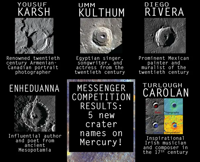
Asteroid Surfaces and Craters

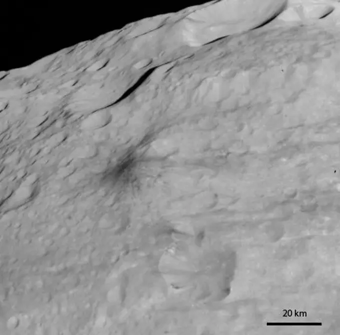
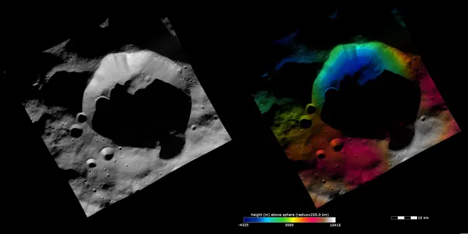
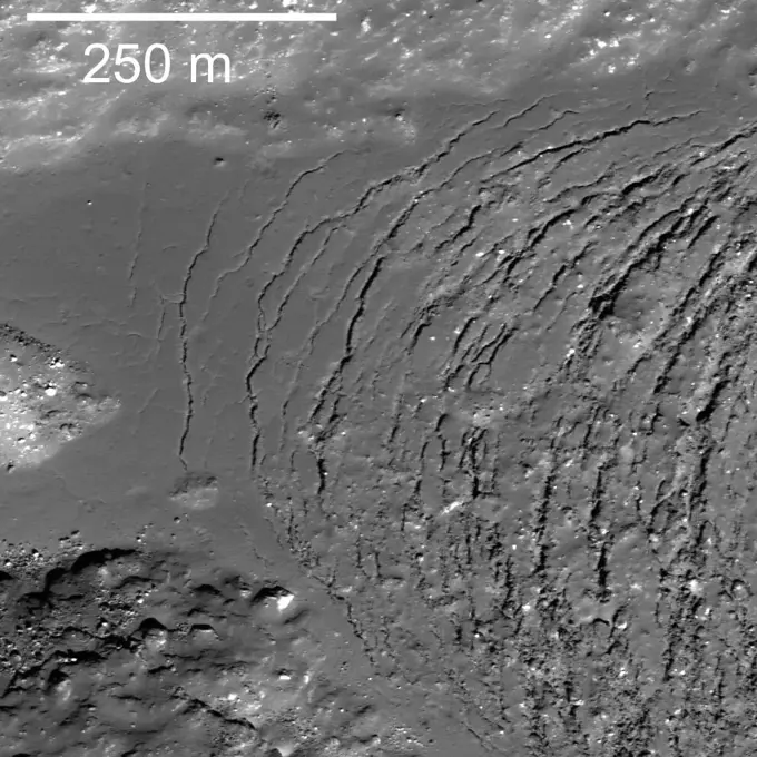
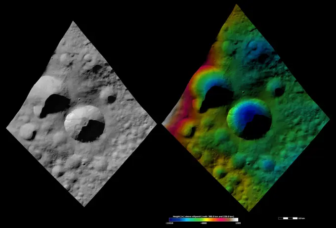
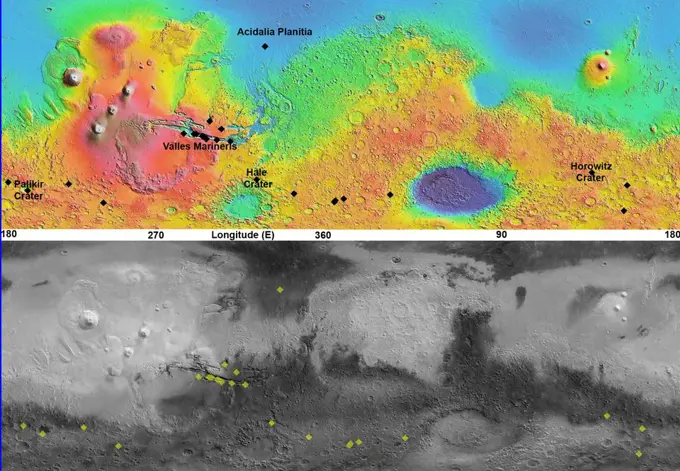
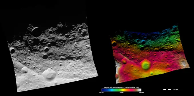
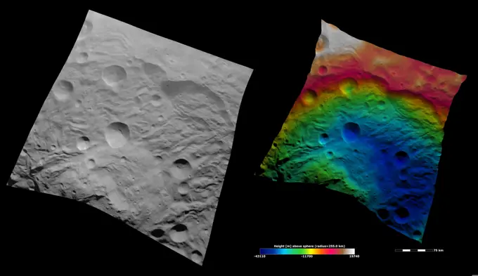
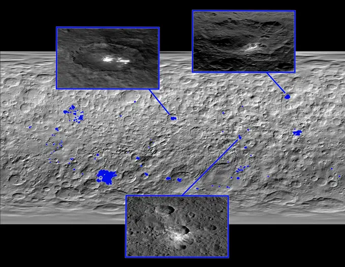
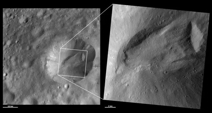
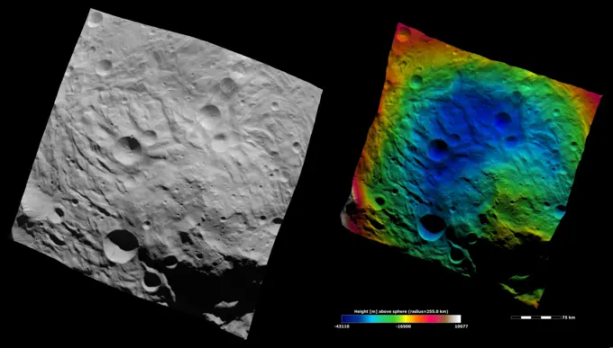
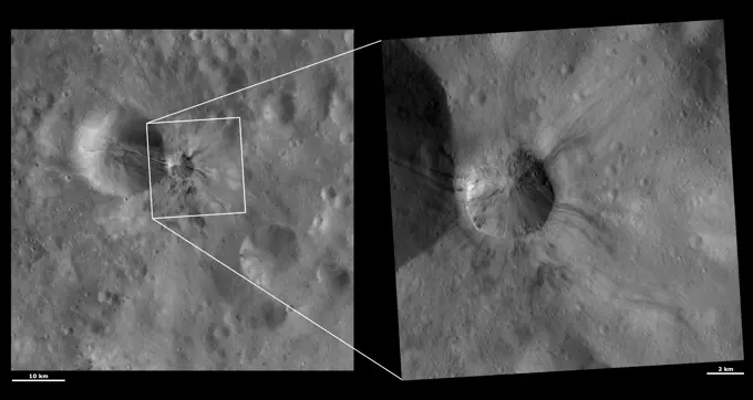
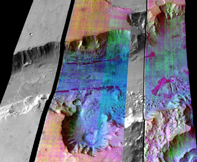
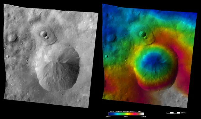
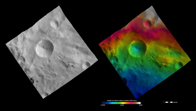
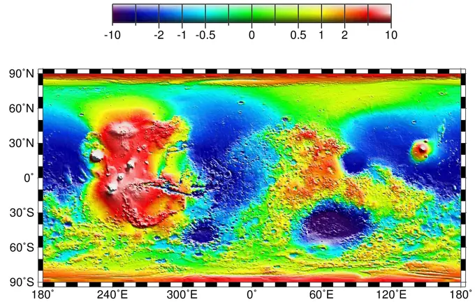
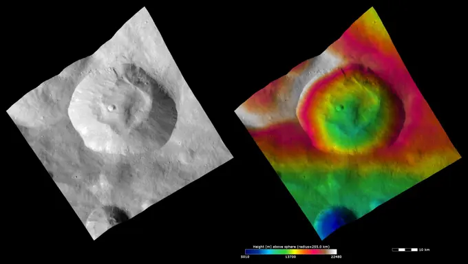
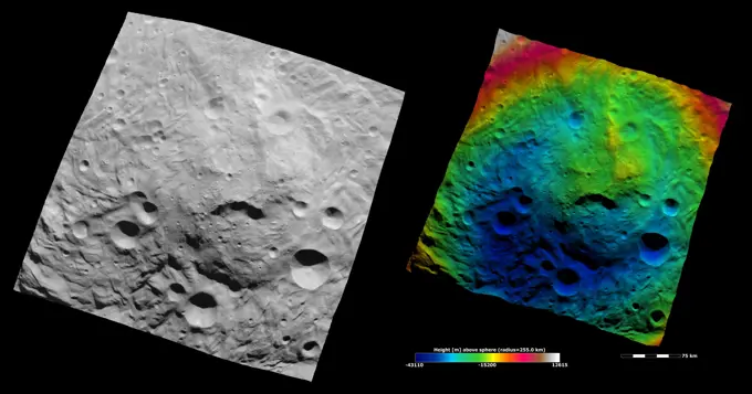
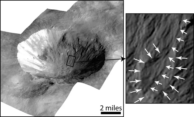
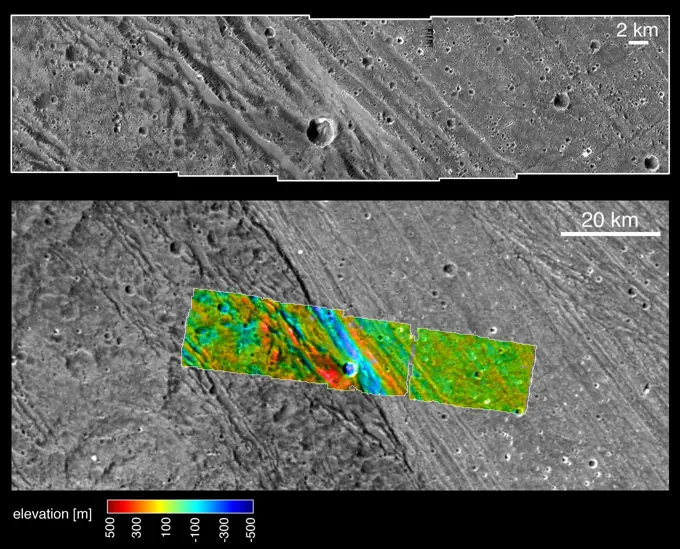
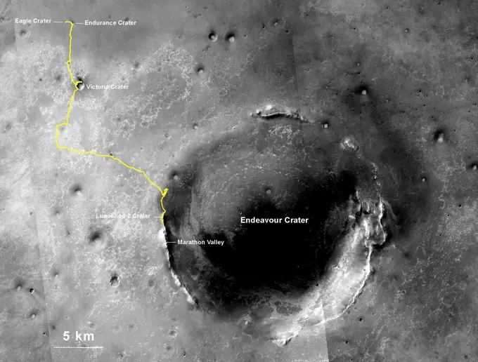
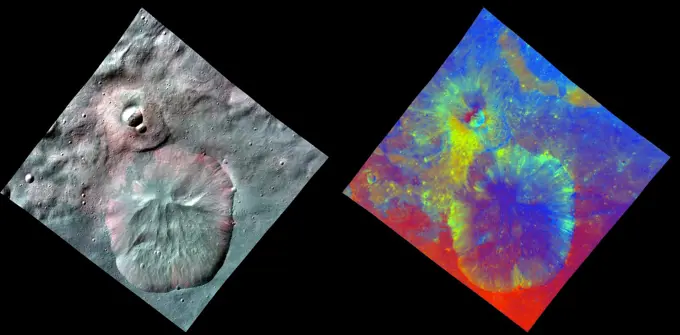
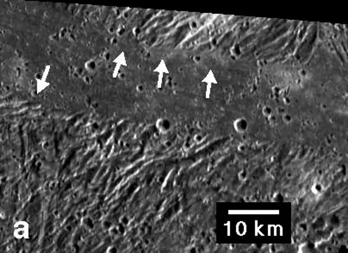
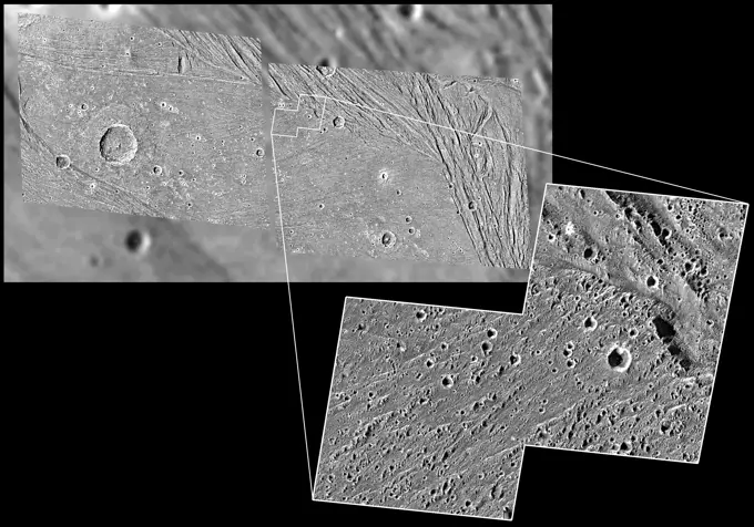
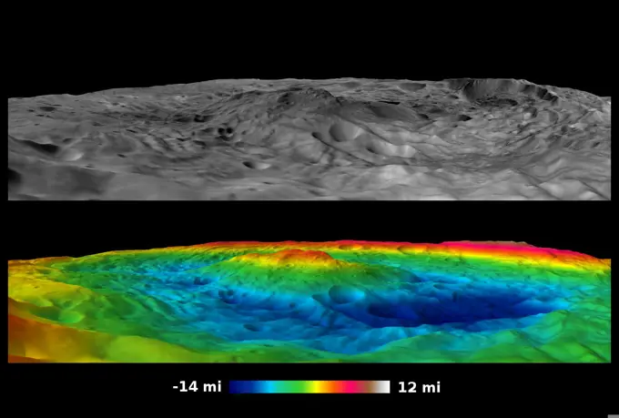
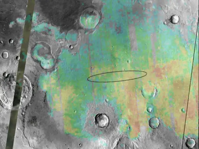
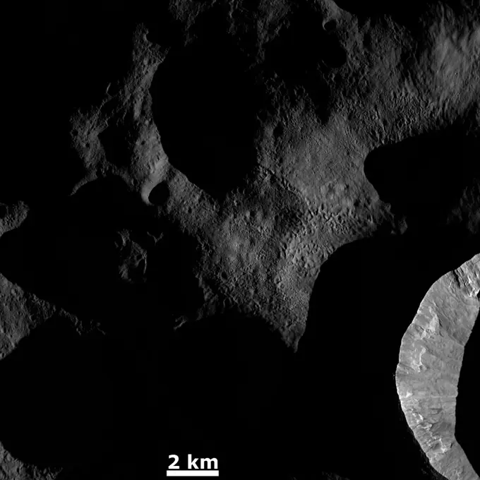
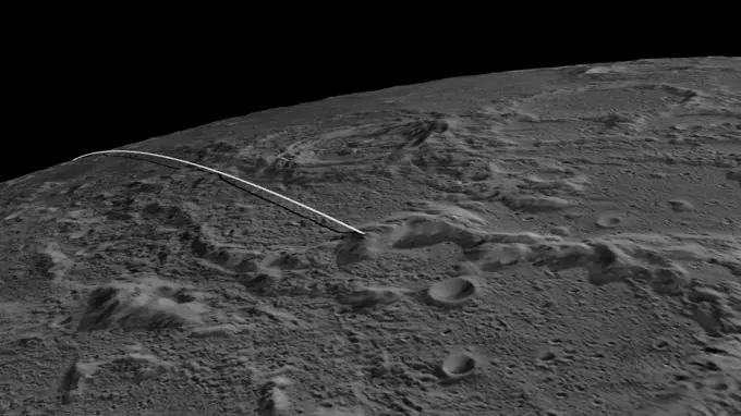
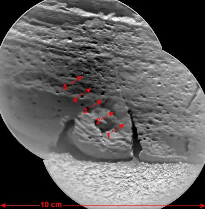
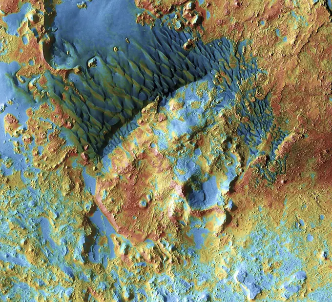
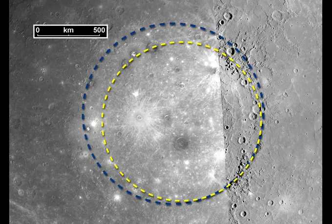
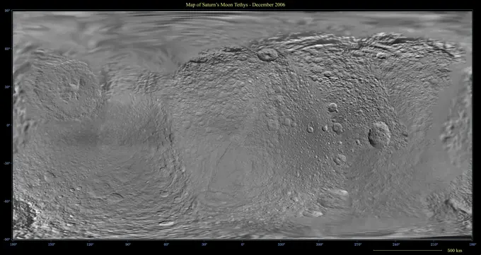
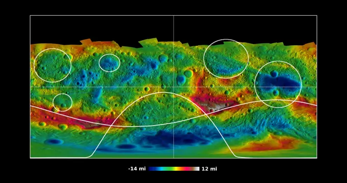
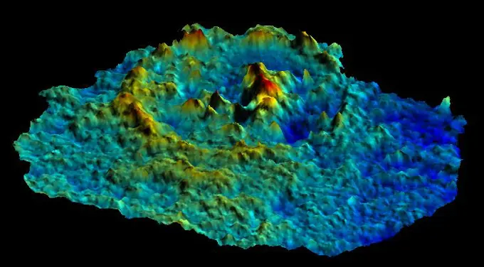
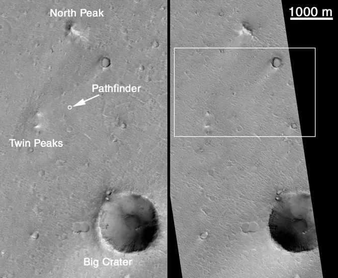
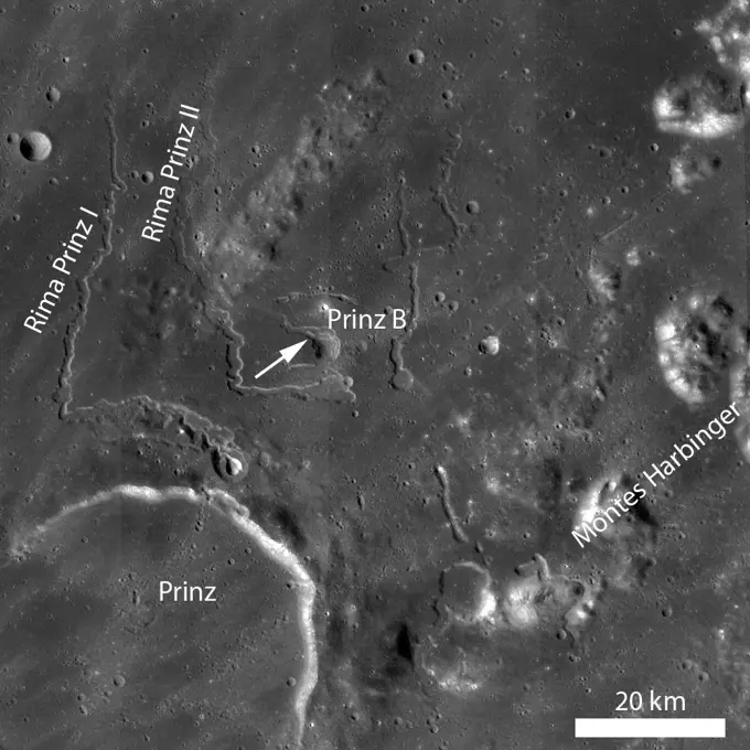
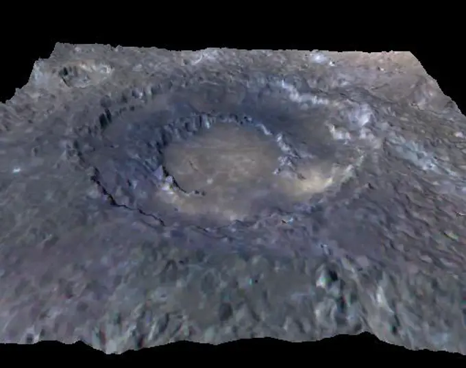
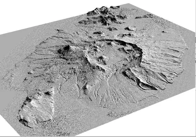
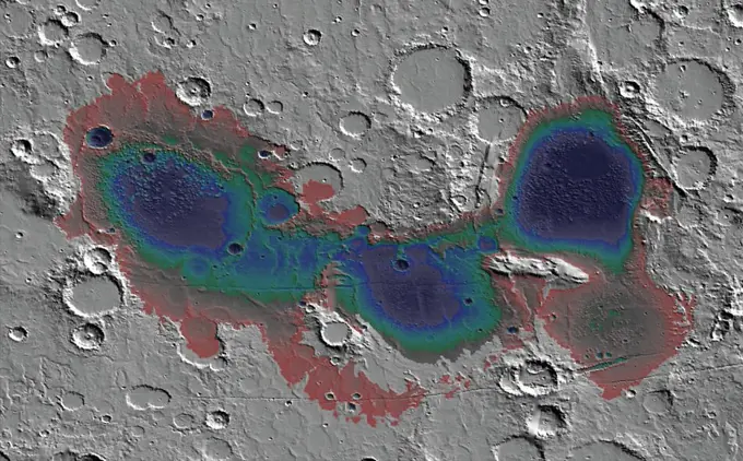
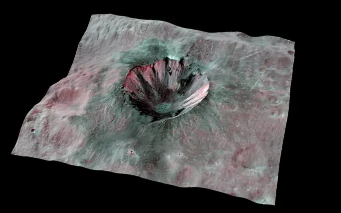
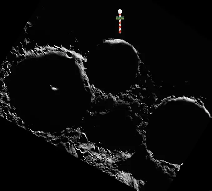
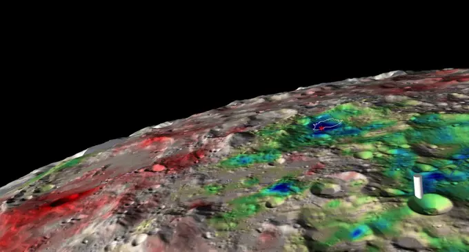
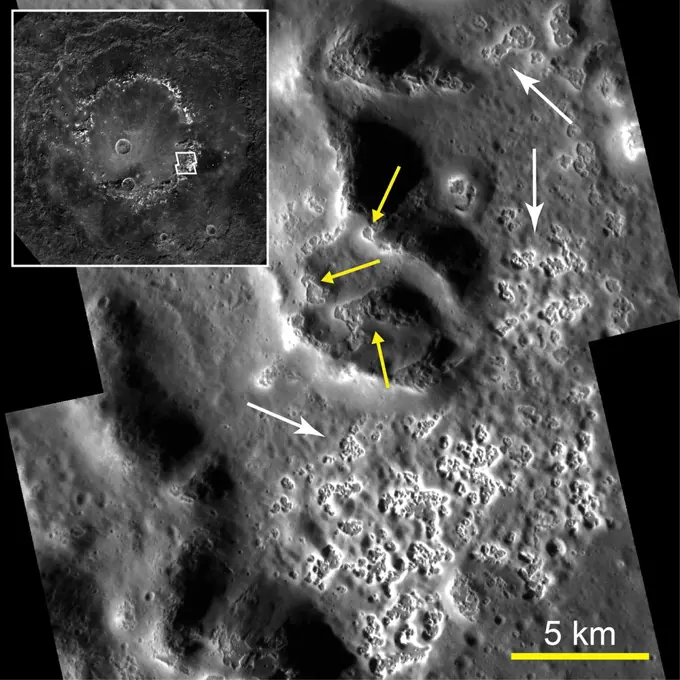
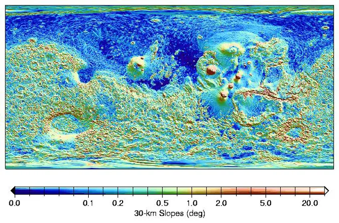
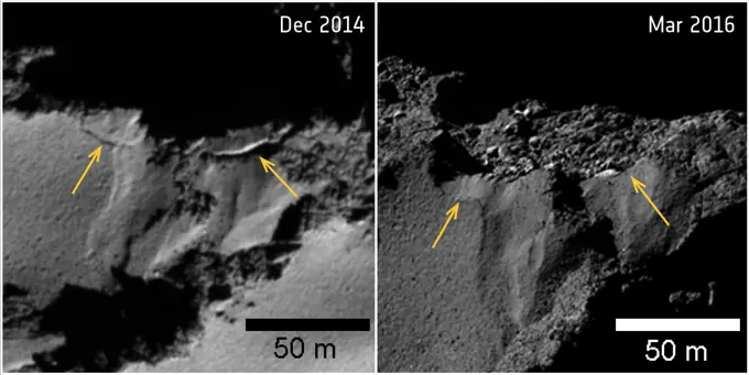
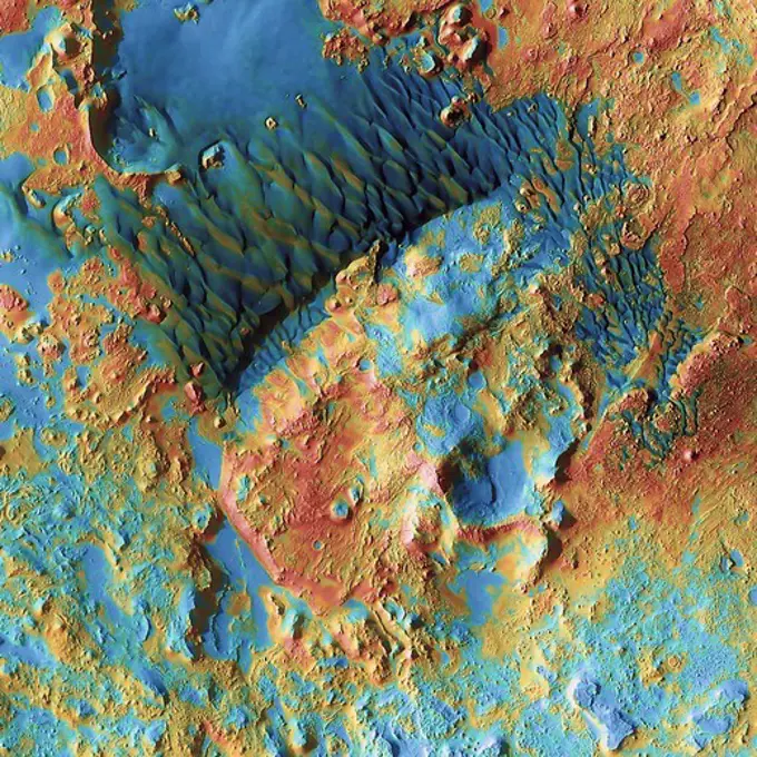
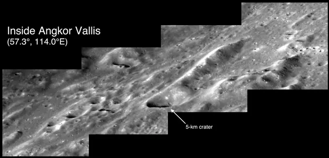
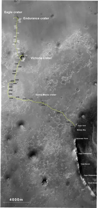
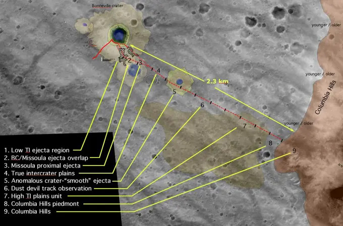
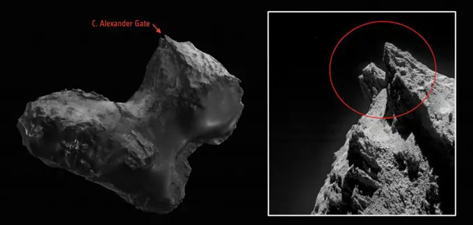
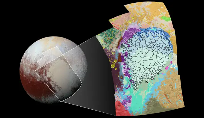
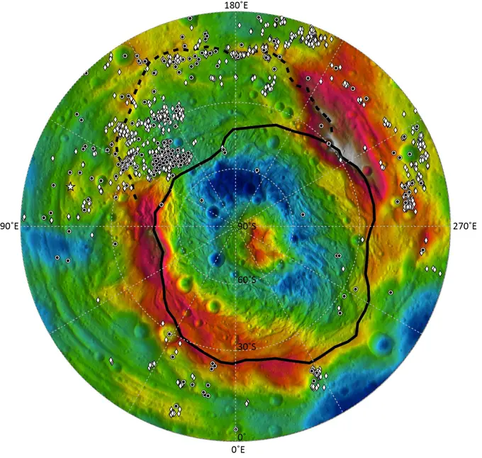
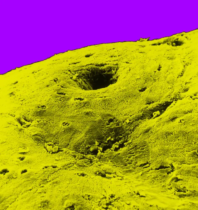
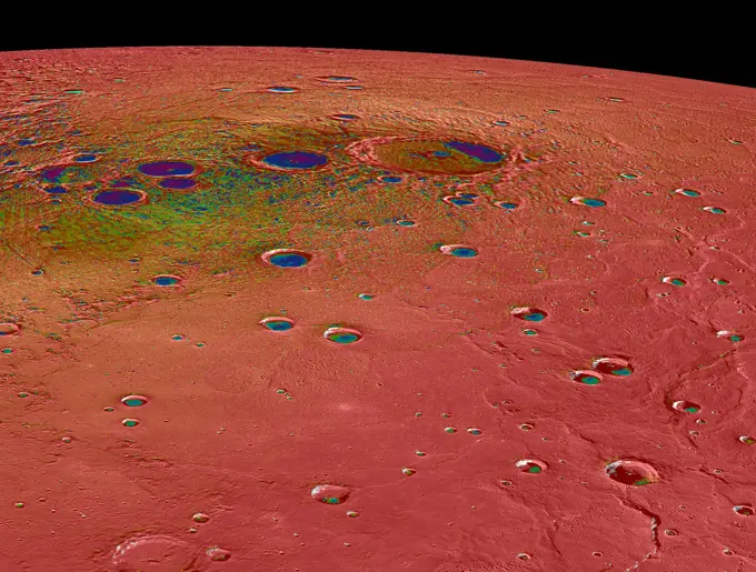
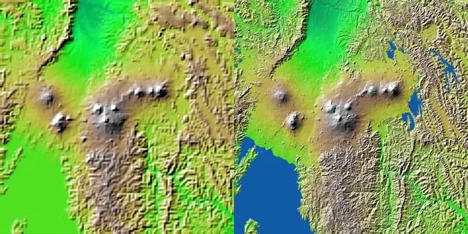
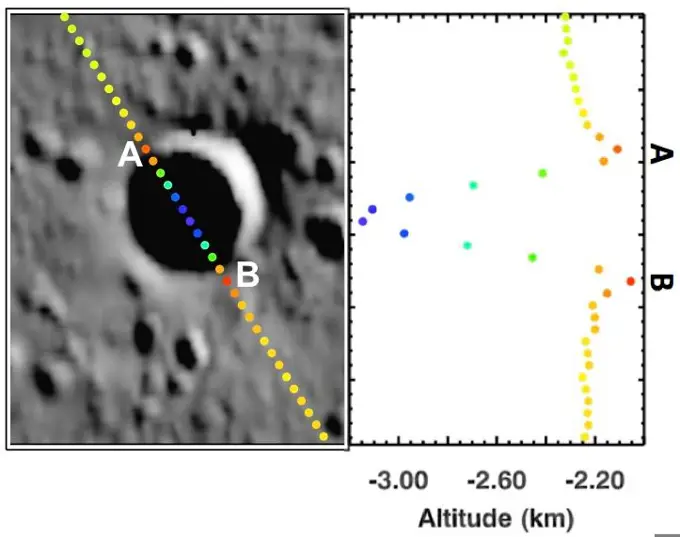
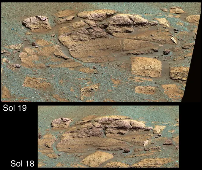
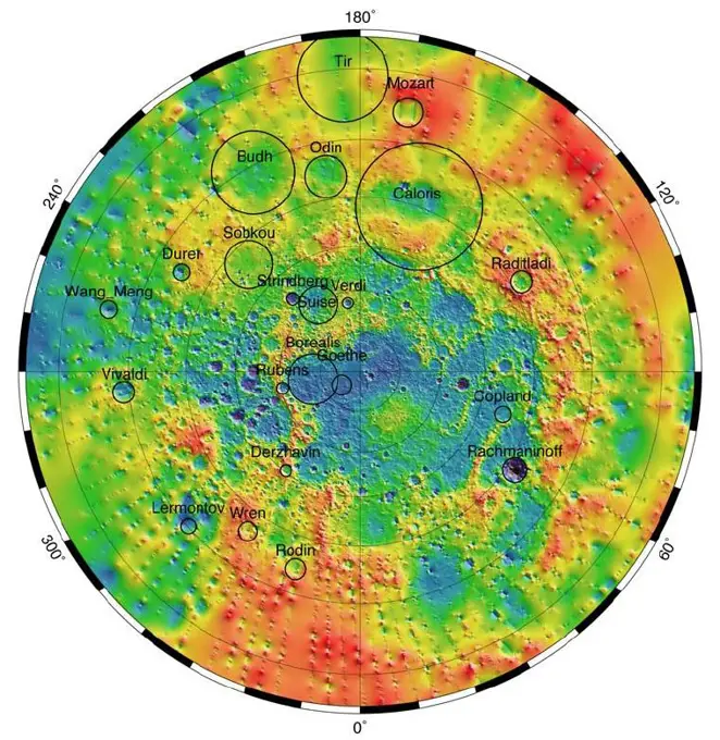
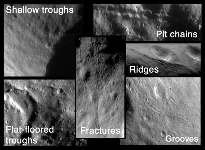
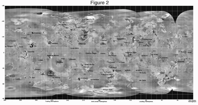
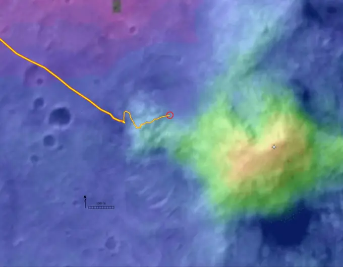
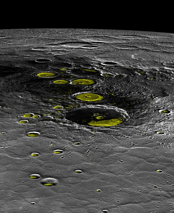
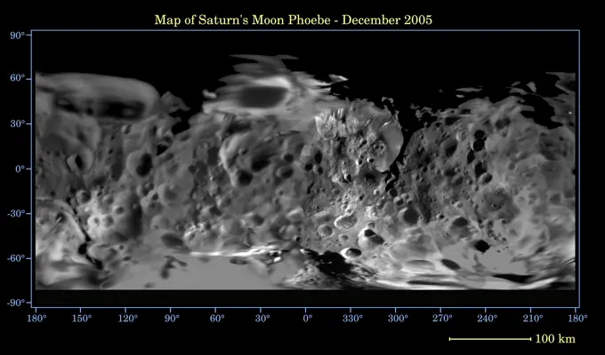
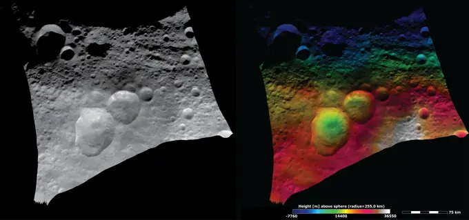
Images capturing the surfaces of asteroids and craters taken by NASA spacecraft, featuring detailed geological formations and textures.

These images from NASA's Dawn spacecraft show the Domitia crater in Vesta's northern hemisphere and the topography of the surrounding region, which includes the 'Snowman' craters.

Assets in this Story

6145-44878684
NASA's Dawn spacecraft obtained this image of the surface of asteroid Vesta with its framing camera on August 12, 2011. This image was taken through the framing camera's clear filter. The image has a resolution of about 260 meters per pixel.
6145-45031077
These images from NASA's Dawn spacecraft are dominated by the 35km diameter Bellicia crater on asteroid Vesta, after which Bellicia quadrangle is named.
6145-44790872
NASA's Lunar Reconnaissance Orbiter captures frozen impact melt flows on the floor of Moore F, a farside highlands crater.
6145-44895806
These images from NASA's Dawn spacecraft are located in asteroid Vesta's Floronia quadrangle, in Vesta's northern hemisphere. Licinia is the large, bowl shaped crater in the center with a sharp rim, which has a scalloped edge.
6145-44987818
This pair of maps based on albedo information from NASA's Mars Odyssey orbiter and topographical information from NASA's Mars Global Surveyor orbiter indicates locations of confirmed sites of recurrent slope linea on Mars.
6145-58967601
These images from NASA's Dawn spacecraft show the Domitia crater in Vesta's northern hemisphere and the topography of the surrounding region, which includes the 'Snowman' craters.
6145-58967491
These images from NASA's Dawn spacecraft shows a region around the asteroid Vesta's equatorial troughs with two different resolutions. More details are visible in the right-hand image such as small linear grooves running roughly parallel to the troughs.
6145-58967666
These images from NASA's Dawn spacecraft show many craters, which have different states of preservation, in Vesta's Bellicia quadrangle in the northern hemisphere.
6145-45021963
These images from NASA's Dawn spacecraft show part of asteroid Vesta's equatorial region, which contains a prominent, deep impact crater (lower center of images) and large troughs (linear depressions).
6145-45021101
NASA's Dawn spacecraft obtained this albedo image of asteroid Vesta with its framing camera on August 11th 2011.
6145-45100572
This map of Ceres, made from images taken by NASA's Dawn spacecraft, shows the locations of about 130 bright areas across the dwarf planet's surface, highlighted in blue. Most of these bright areas are associated with craters.
6145-44902427
These images from NASA's Dawn spacecraft are located in asteroid Vesta's Marcia quadrangle, a few degrees below Vesta's equator. Octavia Crater looks remarkably like a terrestrial landslide.
6145-45021754
NASA's Dawn spacecraft shows the central area of the south polar basin. This view is rotated by approximately 90°.
6145-44900605
These images from NASA's Dawn spacecraft are located in asteroid Vesta's Lucaria Tholus quadrangle, in Vesta's southern hemisphere.
6145-44590848
This image from NASA's Mars Odyssey spacecraft shows part of Ganges Chasma in Valles Marineris. The colors indicate compositional variations in the rocks exposed in the wall and floor of Ganges and in the dust and sand on the rim of the canyon.
6145-45032055
These images from NASA's Dawn spacecraft show Oppia crater on asteroid Vesta, after which Oppia quadrangle is named. Oppia crater is a distinctive crater because it has an unusually shaped rim, which is almost rectangular in form.
6145-45040412
These images from NASA's Dawn spacecraft show Sextilia crater on asteroid Vesta.
6145-44494065
Map of Mars' Topography
6145-45036998
These images from NASA's Dawn spacecraft show Pinaria crater on asteroid Vesta, after which Pinaria quadrangle is named. Many young fresh impact craters are visible on the slumped material.
6145-58967540
NASA's Dawn spacecraft shows the central area of the south polar basin. This view is rotated by approximately 60°.
6145-45086717
This image shows Cornelia Crater on the large asteroid Vesta. On the right is an inset image showing an example of curved gullies, indicated by the short white arrows, and a fan-shaped deposit, indicated by long white arrows.
6145-44515131
Bright-dark boundary and topographical model
6145-45066718
NASA's Opportunity rover, working on Mars since January 2004, passed 25 miles of total driving on the July 27, 2014. The gold line on this map shows Opportunity's route from the landing site inside Eagle Crater, in upper left.
6145-45031287
This image combines two separate views of the giant asteroid Vesta obtained by NASA's Dawn spacecraft. The data reveal a world of many varied, well-separated layers and ingredients.
6145-45112408
Martian gullies as seen in the top image from NASA's MRO resemble gullies on Earth that are carved by liquid water. However, when they are observed with the addition of mineralogical information from CRISM (bottom), no evidence for alteration by water app
6145-44639893
This stereo image mosaic from NASA's Mars Global Surveyor is of 'Columbia Hills.' 3D glasses are necessary to view this image.
6145-44572873
Small Valley Network Near Schiaparelli Crater
6145-45022179
These images from NASA's Dawn spacecraft show part of asteroid Vesta's equatorial region, which contains many different sizes of impact craters.
6145-44520564
Ridges and Troughs in Sippar Sulcus, Ganymede
6145-44917662
Modeling Ice Stability
6145-44507342
This false-color image reveals the scar of a past major impact of a comet or small asteroid on Europa's surface. A city-sized impact crater was viewed by NASA's Galileo spacecraft.
6145-58967442
Spectacular Volcanic Features on Mercury
6145-44958535
In Focus: Paestum Vallis
6145-44515198
Not-so-smooth Bright Terrain of Harpagia Sulcus
6145-44891549
This image from NASA's Dawn spacecraft shows a part of asteroid Vesta's surface reasonably far north into the northern hemisphere which appears washed out because it has been stretched to make features visible that would otherwise be too dark to see.
6145-44888354
Scientists with NASA's Dawn mission have created perspective views of the Rheasilvia impact basin on the giant asteroid Vesta. Rheasilvia is located in Vesta's southern hemisphere.
6145-44607260
Targeting a Hematite-rich Terrain
6145-45043875
This image from NASA's Dawn spacecraft shows the sun illuminating the landscape of asteroid Vesta during a Vestan 'sunrise'; the sun had a low angle relative to Vesta's surface, just as the sun has a low angle in the sky in the morning on Earth.
6145-44918485
This image shows the final flight path for NASA's twin Gravity Recovery and Interior Laboratory (GRAIL) mission spacecraft, which will impact the moon on Dec. 17, 2012, around 2:28 p.m. PST.
6145-44917201
This view of a rock called 'Rocknest 3' combines two images taken by the Chemistry and Camera (ChemCam) instrument on the NASA Mars rover Curiosity and indicates five spots where ChemCam had hit the rock with laser pulses to check its composition.
6145-44745943
Enceladus' Jets
1889-60383487
Mars Topography
4389-1353
A 'Hole' in Mars
6145-44695903
The Great Caloris Basin on Mercury
6145-44665745
This global digital map of Saturn's moon Tethys was created using data taken by the Cassini spacecraft, with gaps in coverage filled in by NASA's Voyager spacecraft data
6145-44888351
This global map from NASA's Dawn mission shows the topography of the giant asteroid Vesta, with the seven most prominent impact basins highlighted.
6145-44845797
New View of Apollo 14
6145-44560976
Pwyll Impact Crater: Perspective View of Topographic Model
6145-44505065
MOC's Highest Resolution View of Mars Pathfinder Landing Site
6145-44840702
Rilles as far as the eye can see in Prinz
6145-44935551
A Bit of an Exaggeration
6145-44530217
This perspective view shows the caldera of the Okmok volcano in Alaska's Aleutian Islands acquired by NASA's Airborne Synthetic Aperture Radar (AIRSAR) in 2001.
6145-45261473
These images show a subtle feature on Ceres called Kwanzaa Tholus. Kwanzaa, meaning first fruits in Swahili, is an African-American festival based on ancient African harvest celebrations, and takes place from December 26 to January 1. A tholus is a type of small mountain. Kwanzaa Tholus measures about 22 by 12 miles (35 by 19 kilometers) and is elevated about 2 miles (3 km) above its surroundings. Because the mountain does not rise sharply above the ground, it is difficult to see in the mosaic on the left, although a small crescent-shaped shadow stands out. The image on the right, which is an elevation map of the area, shows where Kwanzaa Tholus is more prominently. The rounded shape of Kwanzaa Tholus is typical of tholi (plural of tholus) in general, but is different than other examples found on Ceres (like Dalien Tholus) and Mars. This region is particularly rich in this type of feature The current Ceres map shows six named tholi and montes (slightly bigger mountains) in the region (
6145-45258903
The Eridania basin of southern Mars is believed to have held a sea about 3.7 billion years ago, with seafloor deposits likely resulting from underwater hydrothermal activity. This graphic shows estimated depths of water in that ancient sea. A recent estimate of the total water volume of the ancient Eridania sea is about 50,000 cubic miles (210,000 cubic kilometers), about nine times the total volume of North America's Great Lakes. The map covers an area about 530 miles (850 kilometers) wide. This graphic was included in a 2017 report Ancient hydrothermal seafloor deposits in Eridania basin on Mars in Nature Communications. A reference bar indicating color coding of depth, from red, at right, showing depth of about 300 feet (100 meters) to black showing depth more than 10 times that depth. This graphic was included in a 2017 report Ancient hydrothermal seafloor deposits in Eridania basin on Mars in Nature Communications.
6145-44922520
This composite-color view from NASA's Dawn mission shows Cornelia Crater, streaked with dark materials, on the giant asteroid Vesta. You need 3D glasses to view this image.
6145-58967443
See Tyagaraja's Etchings
6145-44881316
Radar-bright Deposits near Mercury's North Pole
6145-44823625
This view of Lyot Crater is a combined mapping by NASA's Project Viking with elevation information from Mars Global Surveyor showing at least one of the nine craters in the northern lowlands of Mars with exposures of hydrated minerals detected from orbit.
6145-44505576
Eruption at Tvashtar Catena, Io, in Color
6145-44572282
Topography Around Europa's Cilix Crater
6145-44920147
North Pole Tidings
1746-19663339
Water Ice Detected Beneath Moons Surface
6145-44958398
This map shows the location of 'Cumberland,' the second rock-drilling target for NASA's Mars rover Curiosity, in relation to the rover's first drilling target, 'John Klein,' within the southwestern lobe of a shallow depression called 'Yellowknife Bay.'
6145-45014381
Stunning Landforms in Raditladi Basin
6145-44511642
MOLA Global Map of Surface Gradients on Mars
6145-45129734
Several sites of cliff collapse on comet 67P/Churyumov-Gerasimenko were identified during ESA's Rosetta's mission. The yellow arrows mark the fractures where the detachment occurred.
4389-1557
Arabia Dunes (Digital Composite) Seen by Mars Odyssey
6145-45085642
Inside Angkor Vallis
6145-44986921
These two images come from the HiRISE camera on NASA's Mars Reconnaissance Orbiter. Images of locations in Gale Crater taken from orbit around Mars reveal evidence of erosion in recent geological times and development of small scarps, or vertical surfaces
6145-58967144
The yellow line on this map shows where NASA's Mars Rover Opportunity has driven from the place where it landed in January 2004, inside Eagle crater, at the upper left end of the track, to a point approaching the rim of Endeavour crater.
6145-44612019
Getting There is Half the Fun
6145-44611263
To 'Bonneville' and Beyond
6145-44918195
A linear gravity anomaly intersecting the Crisium basin on the nearside of the moon has been revealed by NASA's GRAIL mission. The GRAIL gravity gradient data are shown at left, with the location of the anomaly indicated.
6145-44530241
These images acquired on October 11, 2001 by NASA's Terra satellite portray an occluded extratropical cyclone situated in the Southern Ocean, about 650 kilometers south of the Eyre Peninsula, South Australia.
6145-45098751
Scientists from the European Space Agency's Rosetta team have honored two late team members by naming comet features after them. The comet is 67P/Churyumov-Gerasimenko, where the mission successfully landed a probe.
6145-45258100
This geological map covers a portion of Pluto's surface that measures 1,290 miles (2,070 kilometers) from top to bottom, and includes the vast nitrogen-ice plain informally named Sputnik Planum and surrounding terrain. The map is overlain with colors that represent different geological terrains. Each terrain, or unit, is defined by its texture and morphology -- smooth, pitted, craggy, hummocky or ridged, for example. How well a unit can be defined depends on the resolution of the images that cover it. All of the terrain in this map has been imaged at a resolution of approximately 1,050 feet (320 meters) per pixel or better, meaning scientists can map units with relative confidence. The various blue and greenish units that fill the center of the map represent different textures seen across Sputnik Planum, from the cellular terrain in the center and north, to the smooth and pitted plains in the south. The black lines represent the troughs that mark the boundaries of cellular regions in t
6145-44922530
This map shows the distribution of dark materials throughout the southern hemisphere of the giant asteroid Vesta. The circles, diamonds, and stars show where the dark material appears in craters, spots and topographic highs.
824-63128358
Colon mucosa in SEM x 600. The colon mucosa is constituted of an epithelium, glands, a connective tissue. The glands of this mucosa (crypts of Lieberkühn) have a precise physiological function in the absorption of food (secretion of intestinal juice).
6145-45090295
Hot and Cold
6145-45263300
An annotated image of the surface of Mars, taken by the HiRISE camera on NASA's Mars Reconnaissance Orbiter (MRO) on May 30, 2014. The contrast has been enhanced in this image to better show the region where InSight landed on Nov. 26, 2018. The labels show the approximate position of NASA's InSight lander in Elysium Planitia. Overlaid on top are the direction of the vibrations detected by InSight's science instruments. The diagonal lines, faintly seen moving from upper left corner to the lower right corner of the image, show the paths of dust devils on the Martian surface. The vibrations recorded by InSight line up with the direction of the dust devil motion.
6145-44857135
These images compare surface features observed by NASA's Cassini spacecraft at the Xanadu region on Saturn's moon Titan (left), and features observed by NASA's Galileo spacecraft on Jupiter's cratered moon Callisto (right).
6145-45248275
On Earth, the longitude of the Royal Observatory in Greenwich, England is defined as the prime meridian, or the zero point of longitude. Locations on Earth are measured in degrees east or west from this position. The prime meridian was defined by international agreement in 1884 as the position of the large transit circle, a telescope in the Observatory's Meridian Building. The transit circle was built by Sir George Biddell Airy, the 7th Astronomer Royal, in 1850. (While visual observations with transits were the basis of navigation until the space age, it is interesting to note that the current definition of the prime meridian is in reference to orbiting satellites and Very Long Baseline Interferometry (VLBI) measurements of distant radio sources such as quasars. This International Reference Meridian is now about 100 meters east of the Airy Transit at Greenwich.) For Mars, the prime meridian was first defined by the German astronomers W. Beer and J. H. Mädler in 1830-32. They used a sm
6145-44579125
Volcanic, tectonic, erosional and sedimentary landforms are all evident in this comparison of two elevation models of a region along the East African Rift at Lake Kivu. The area shown covers parts of Congo, Rwanda and Uganda.
6145-45069581
Simple Shapes
6145-45072780
This image depicts the primary landing site on comet 67P/Churyumov-Gerasimenko chosen for the European Space Agency's Rosetta mission.
6145-44609374
El Capitan
6145-44881315
Mercury's Topography from MLA
6145-44565628
Io imaging during Galileo's 24th orbit
6145-44518522
The Many Faces of Eros
6145-45129736
This image showcases changes identified in high-resolution images of Comet 67P/Churyumov-Gerasimenko during more than two years of monitoring by ESA's Rosetta spacecraft.
6145-44857134
These side-by-side images obtained by NASA's Cassini spacecraft show the feature named Tortola Facula on Saturn's moon Titan.
6145-44888356
This colorized map from NASA's Dawn mission shows the distribution of minerals across the surface of the giant asteroid Vesta. It was made from spectra -- or data collected in different wavelengths of radiation.
6145-44638525
Prime Time for Rhea
6145-44818928
This global map of Saturn's moon Mimas was created using images taken during NASA's Cassini spacecraft flybys, with NASA's Voyager images filling in the gaps in Cassini's coverage.
6145-45090567
Small and Young
6145-44918749
This map traces where NASA's Mars rover Curiosity drove between landing at a site subsequently named 'Bradbury Landing,' where the rover entered a shallow depression called 'Yellowknife Bay' on Sol 125 (Dec.12).
6145-45092322
Measurements from NASA's MESSENGER's MLA instrument during the spacecraft's greater than four-year orbital mission have mapped the topography of Mercury's northern hemisphere in great detail.
6145-44918208
GRAIL's Gravity Tour of the Moon
6145-44918205
Map of Moon's Crust
6145-44585248
Potential Source of Sulfur Flow on Io
6145-44886314
This frame from a video from NASA's Dawn mission shows that the gravity field of Vesta closely matches the surface topography of the giant asteroid Vesta.
6145-44881550
Highs and Lows of Goethe
6145-44901635
This composite image, with magnified insets, depicts the first laser test by the Chemistry and Camera, or ChemCam, instrument aboard NASA's Curiosity Mars rover.
6145-44831994
Diviner Global Composition
6145-44572284
Highest Resolution Mosaic of Io
6145-44625917
Digital Elevation Map of Spirit's Trek
6145-45085399
A Change of Perspective
6145-45010648
The terrain model of Vesta's southern hemisphere shows a big circular structure, its rim rising above the interior of the structure. This false-color map of the giant asteroid Vesta is from the framing camera aboard NASA's Dawn spacecraft.
6145-44639643
This global digital map of Saturn's moon Phoebe was created using data taken during NASA's Cassini spacecraft's close flyby of the small moon in June 2004. The map is an equidistant projection and has a scale of 233 meters (764 feet) per pixel
6145-44705743
Map of Dione - May 2008
6145-45104967
This map shows the route driven by NASA's Curiosity Mars rover from the location where it landed in August 2012 to its location in early March 2016, approaching a geological waypoint called Naukluft Plateau.
6145-44768596
These drawings depict explanations for the source of intense heat that has been measured coming from Enceladus' south polar region. These models predict that water could exist in a deep layer as an ocean or sea and also near the surface.
6145-44718032
S72-01712 (July 1972) --- A vertical view of the Apollo 17 landing site in the Taurus-Littrow area of the lunar nearside, with an overlay showing the Lunar Roving Vehicle traverse proposed for the third extravehicular activity. The scale at the bottom is measured in kilometers. One kilometer equals 0.6214 statute miles. The coordinates of the Apollo 17 touchdown point are 30 degrees 44 minutes 58 seconds east longitude and 20 degrees 9 minutes 50 seconds north latitude. This photograph was taken from lunar orbit on an earlier Apollo mission.
6145-45034018
NASA's Dawn spacecraft has spiraled closer and closer to the surface of the giant asteroid Vesta. These images were obtained by Dawn's framing camera in the three phases of its campaign since arriving at Vesta in mid-2011.
6145-45062526
This map shows in red the route driven by NASA's Curiosity Mars rover from its landing site at 'Bradbury Landing.' The white line shows the planned route to reach destinations on Mount Sharp. Sol 669 will complete one Martian year.
6145-44899264
This image shows the topography, with shading added, around the area where NASA's Curiosity rover is slated to land on Aug. 5 PDT (Aug. 6 EDT). The red oval indicates the targeted landing area for the rover known as the 'landing ellipse.'
6145-45123733
This map shows the route driven by NASA's Curiosity Mars rover (blue line) and locations where the rover's ChemCam instrument detected the element boron (dots, colored by abundance of boron according to the key at right).
6145-44506838
Evidence for Recent Liquid Water on Mars: Basic Features of Martian Gullies
6145-44626153
First Flyby of Dione
6145-44910191
This false-color map shows the area within Gale Crater on Mars, where NASA's Curiosity rover landed on Aug. 5, 2012 PDT (Aug. 6, 2012 EDT). The rover is heading toward Glenelg, just to the lower right of Bradbury.
6145-44834781
This false-color image, made from infrared data obtained by NASA's Cassini spacecraft, shows dark and bright clouds on Saturn associated with thunderstorm activity.
6145-44562531
NASA's Galileo spacecraft obtained this image of half of Io's disk in darkness on Sept. 19, 1997.
6145-45000772
A region known as 'Cape York' on the western rim of Endeavour Crater, where the Opportunity rover worked for 20 months, is highlighted in these images from NASA's Mars Reconnaissance Orbiter.
6145-44507891
These images from NASA's Terra satellite are of the southeast portion of Georgian Bay in Ontario, Canada, acquired on March 6, 2000, during Terra orbit 1155.
6145-44942273
This illustration schematically shows where the Shallow Radar instrument on NASA's Mars Reconnaissance Orbiter detected flood channels that had been buried by lava flows in the Elysium Planitia region of Mars.
6145-44841830
This map shows the path that NASA's Mars Exploration Rover Spirit followed from the 743rd Martian day (Feb. 4, 2009), or sol, to Sol 2471 (Dec. 15, 2010). Spirit has been at a sand-trap location called 'Troy' since April 2009.
6145-44519263
Eruption at Tvashtar Catena on Io
6145-44875398
Mawrth Vallis, a Finalist Not Selected as a Landing Site for Curiosity
6145-44614693
Spirit's Express Route to 'Columbia Hills'
6145-44563583
Month-long Evolution of the D/G Jupiter Impact Sites from Comet P/Shoemaker-Levy 9
6145-45092611
Five previously unnamed craters on Mercury now have names. Shown here are Carolan, Enheduanna, Karsh, Kulthum, and Rivera as seen by NASA's MESSENGER spacecraft.