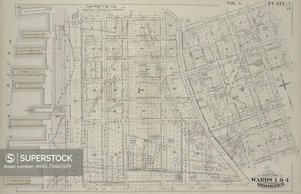
Vol. 5. Plate C. Map bound by Poplar St., Sands St., Jay St., Pearl St., Johnson St., Pierrepont St., and the East River; including Middagh St., High St., Cranberry St., Orange St., Nassau St., Pineapple St., Concord St., Clark St., Tillary St., Love Lane, Furman St., Columbia Heights, Willow St., Hicks St., College Pl., Henry St., Monroe St., Clinton St., Liberty St., Washington St., and Adams St., 1880., Brooklyn, New York. Publisher, G.M. Hopkins & Co. Real property, New York (State)
SuperStock offers millions of photos, videos, and stock assets to creatives around the world. This image of Vol. 5. Plate C. Map bound by Poplar St., Sands St., Jay St., Pearl St., Johnson St., Pierrepont St., and the East River; including Middagh St., High St., Cranberry St., Orange St., Nassau St., Pineapple St., Concord St., Clark St., Tillary St., Love Lane, Furman St., Columbia Heights, Willow St., Hicks St., College Pl., Henry St., Monroe St., Clinton St., Liberty St., Washington St., and Adams St., 1880., Brooklyn, New York. Publisher, G.M. Hopkins & Co. Real property, New York (State) by Artokoloro is available for licensing today.
Looking for a license?
Click here, and we'll help you find it! Questions? Just ask!
Click here, and we'll help you find it! Questions? Just ask!
DETAILS
Image Number: 4443-75465599Rights ManagedCredit Line:Artokoloro/SuperStockCollection:Artokoloro Model Release:NoProperty Release:NoResolution:6364×4099