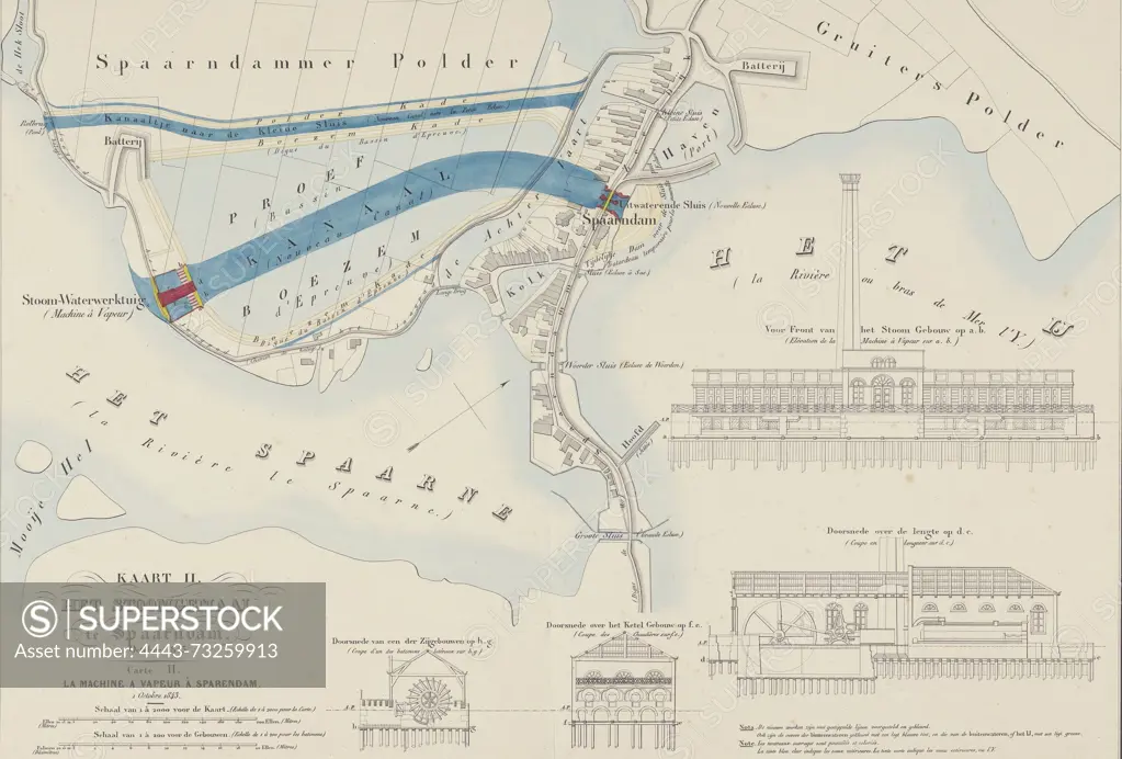
Suite of ten maps and plates of the drainage of the Haarlemmermeer 1843-1860, Map II. The Steam Pumping Station at Spaarndam, 1 October 1843, Netherlands, verso - stamped, Map showing the location of Spaarndam between the Spaarne and the IJ, 1 October 1843. Right and at the bottom two cross-sections of the steam pumping station at Spaarndam and of some outbuildings. Inscriptions in Dutch and French. Part of a suite of ten plates of the draining of the Haarlemmermeer, 1843-1860., print, prent, map, prints, Frederik Muller Historieplaten, height 560 mm, width 750 mm, print maker, prentmaker, 1843 - 1861, paper, papier, lithografie (technique), hand kleuren
SuperStock offers millions of photos, videos, and stock assets to creatives around the world. This image of Suite of ten maps and plates of the drainage of the Haarlemmermeer 1843-1860, Map II. The Steam Pumping Station at Spaarndam, 1 October 1843, Netherlands, verso - stamped, Map showing the location of Spaarndam between the Spaarne and the IJ, 1 October 1843. Right and at the bottom two cross-sections of the steam pumping station at Spaarndam and of some outbuildings. Inscriptions in Dutch and French. Part of a suite of ten plates of the draining of the Haarlemmermeer, 1843-1860., print, prent, map, prints, Frederik Muller Historieplaten, height 560 mm, width 750 mm, print maker, prentmaker, 1843 - 1861, paper, papier, lithografie (technique), hand kleuren by Artokoloro is available for licensing today.
Looking for a license?
Click here, and we'll help you find it! Questions? Just ask!
Click here, and we'll help you find it! Questions? Just ask!
DETAILS
Image Number: 4443-73259913Rights ManagedCredit Line:Artokoloro/SuperStockCollection:Artokoloro Model Release:NoProperty Release:NoResolution:4938×3339