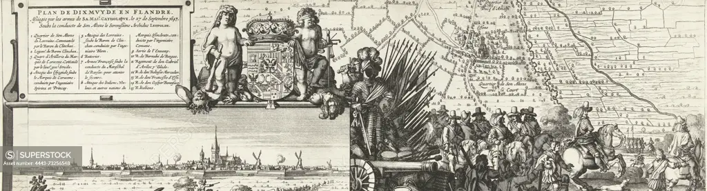
Southern Netherlands, Plan de Dixmuyde en Flandre, Assiegée par les armes de Sa. Mai.é Catholique, le 27 de Septembre 1647, Soubs la conduicte de Son Alteze le Serenissime Archiduc Leopolde, Map of the siege of Diksmuide (right sheet), 1647, Map of the siege of the town of Diksmuide in Flanders on the French by the Spanish under the command of governor Leopold Willem. Right part of a map consisting of three loose sheets, with a part of the map showing officers on horseback near a forest at the bottom., map, print, prent, prints, Frederik Muller Historieplaten, height 530 mm, width 148 mm, print maker, prentmaker, 1647 - 1647, second quarter 17th century, paper, papier, etching, etchings
SuperStock offers millions of photos, videos, and stock assets to creatives around the world. This image of Southern Netherlands, Plan de Dixmuyde en Flandre, Assiegée par les armes de Sa. Mai.é Catholique, le 27 de Septembre 1647, Soubs la conduicte de Son Alteze le Serenissime Archiduc Leopolde, Map of the siege of Diksmuide (right sheet), 1647, Map of the siege of the town of Diksmuide in Flanders on the French by the Spanish under the command of governor Leopold Willem. Right part of a map consisting of three loose sheets, with a part of the map showing officers on horseback near a forest at the bottom., map, print, prent, prints, Frederik Muller Historieplaten, height 530 mm, width 148 mm, print maker, prentmaker, 1647 - 1647, second quarter 17th century, paper, papier, etching, etchings by Artokoloro is available for licensing today.
Looking for a license?
Click here, and we'll help you find it! Questions? Just ask!
Click here, and we'll help you find it! Questions? Just ask!
DETAILS
Image Number: 4443-73256548Rights ManagedCredit Line:Artokoloro/SuperStockCollection:Artokoloro Model Release:NoProperty Release:NoResolution:6488×1756