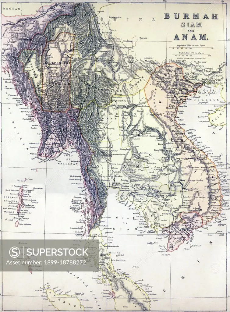
A Political map of mainland Southeast Asia including Burma, Thailand, Laos, Cambodia and Vietnam, as well as peninsular Malaysia, the Andaman and Nicobar Islands, and part of Sumatra. Published, apparently, just before the 3rd Anglo-Burmese War (1885-86) which would extinguish Burmese independence, it shows 'Independent Burma' in an approximate rectangle around Mandalay. To the east lies the 'Independent Shan Country' encompassing the Burmese Shan States and northern Laos. East of this again is Tonkin, or northern Vietnam, where the 'Independent Tribes' represent the semi-independent Tai domain of Sipsongchuthai, absorbed by the French in 1888 and now a part of Vietnam. South of this again, the 'Shan States' encompass the former Lan Na Kingdom centred on Chiang Mai to the west, and the Lao kingdoms of Luang Prabang, Vientiane and Champassak to the east. Chiang Mai is no longer shown as extending west of the Salween River, as is the case in some earlier European maps. Interestingly (and
SuperStock offers millions of photos, videos, and stock assets to creatives around the world. This image of A Political map of mainland Southeast Asia including Burma, Thailand, Laos, Cambodia and Vietnam, as well as peninsular Malaysia, the Andaman and Nicobar Islands, and part of Sumatra. Published, apparently, just before the 3rd Anglo-Burmese War (1885-86) which would extinguish Burmese independence, it shows 'Independent Burma' in an approximate rectangle around Mandalay. To the east lies the 'Independent Shan Country' encompassing the Burmese Shan States and northern Laos. East of this again is Tonkin, or northern Vietnam, where the 'Independent Tribes' represent the semi-independent Tai domain of Sipsongchuthai, absorbed by the French in 1888 and now a part of Vietnam. South of this again, the 'Shan States' encompass the former Lan Na Kingdom centred on Chiang Mai to the west, and the Lao kingdoms of Luang Prabang, Vientiane and Champassak to the east. Chiang Mai is no longer shown as extending west of the Salween River, as is the case in some earlier European maps. Interestingly (and by Pictures From History/Universal Images is available for licensing today.
Looking for a license?
Click here, and we'll help you find it! Questions? Just ask!
Click here, and we'll help you find it! Questions? Just ask!
DETAILS
Image Number: 1899-18788272Rights ManagedCredit Line:Pictures From History/Universal Images/SuperStockCollection: