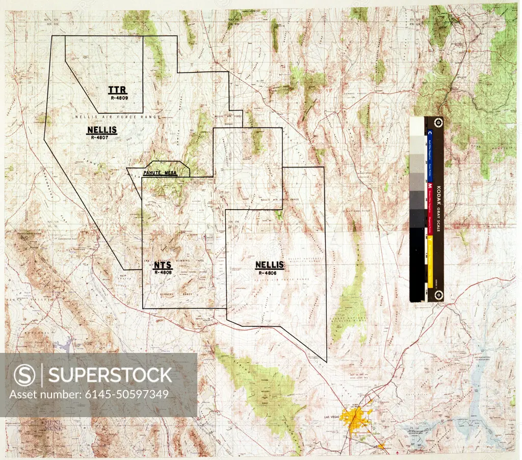
A810327 NELLIS AIR FORCE RANGE AERIAL MAP ADAM TRUJILLO (Project Engineer) JUN 9 81 EG&G/NTS PHOTO LAB Publication Date: 6/9/1981 AIR FORCE BASES; EDGERTON, GERMESHAUSEN & GRIER; EG&G; LAS VEGAS; MAPS; MAPS-NTS; NELLIS AERIAL MAP; NELLIS AIR FORCE BASE; NELLIS AIR FORCE RANGE; NEVADA; NEVADA TEST SITE; NTS; NUCLEAR TESTING; TEST SITES; TONOPAH; TONOPAH TEST RANGE; TRUJILLO, ADAM; TTR; UGT; UNDERGROUND TESTING; NELLIS AFR AERIAL MAP historical images. 1972 - 2012. Department of Energy. National Nuclear Security Administration. Photographs Related to Nuclear Weapons Testing at the Nevada Test Site.
SuperStock offers millions of photos, videos, and stock assets to creatives around the world. This image of A810327 NELLIS AIR FORCE RANGE AERIAL MAP ADAM TRUJILLO (Project Engineer) JUN 9 81 EG&G/NTS PHOTO LAB Publication Date: 6/9/1981 AIR FORCE BASES; EDGERTON, GERMESHAUSEN & GRIER; EG&G; LAS VEGAS; MAPS; MAPS-NTS; NELLIS AERIAL MAP; NELLIS AIR FORCE BASE; NELLIS AIR FORCE RANGE; NEVADA; NEVADA TEST SITE; NTS; NUCLEAR TESTING; TEST SITES; TONOPAH; TONOPAH TEST RANGE; TRUJILLO, ADAM; TTR; UGT; UNDERGROUND TESTING; NELLIS AFR AERIAL MAP historical images. 1972 - 2012. Department of Energy. National Nuclear Security Administration. Photographs Related to Nuclear Weapons Testing at the Nevada Test Site. by Piemags/PL Photography Limited is available for licensing today.
Looking for a license?
Click here, and we'll help you find it! Questions? Just ask!
Click here, and we'll help you find it! Questions? Just ask!
DETAILS
Image Number: 6145-50597349Royalty FreeCredit Line:Piemags/PL Photography Limited/SuperStockCollection: