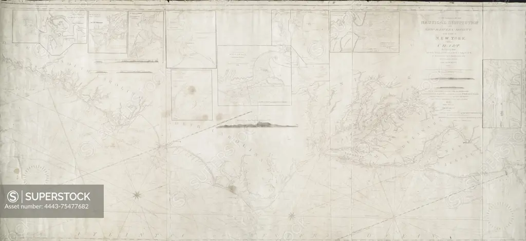
To the members of the Nautical Institution and Ship-masters' Society of the city of New York, this chart, extending from lat. 40°15 N., long. 72°15 W., to lat. 22°35 N., long. 80°25 W., is respectfully dedicated., 1824., New York. Publisher, Wm. Hooker. Coasts Florida, Atlantic Coast (U.S.), Bahamas, Straits of Florida., A nautical chart depicting coastal regions from latitude 40°15 N, longitude 72°15 W to latitude 22°35 N, longitude 80°25 W, including parts of the Atlantic Coast of the U.S., Florida, and the Bahamas, published in 1824 by Wm. Hooker
SuperStock offers millions of photos, videos, and stock assets to creatives around the world. This image of To the members of the Nautical Institution and Ship-masters' Society of the city of New York, this chart, extending from lat. 40°15 N., long. 72°15 W., to lat. 22°35 N., long. 80°25 W., is respectfully dedicated., 1824., New York. Publisher, Wm. Hooker. Coasts Florida, Atlantic Coast (U.S.), Bahamas, Straits of Florida., A nautical chart depicting coastal regions from latitude 40°15 N, longitude 72°15 W to latitude 22°35 N, longitude 80°25 W, including parts of the Atlantic Coast of the U.S., Florida, and the Bahamas, published in 1824 by Wm. Hooker by Artokoloro is available for licensing today.
Looking for a license?
Click here, and we'll help you find it! Questions? Just ask!
Click here, and we'll help you find it! Questions? Just ask!
DETAILS
Image Number: 4443-75477682Rights ManagedCredit Line:Artokoloro/SuperStockCollection:Artokoloro Model Release:NoProperty Release:NoResolution:7597×3494