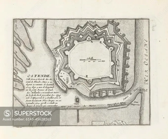
Map of Ostend, approx. 1693-1695; Ostende, Ville Forte, et port de Mer, du Comté de Flandre (...); Les Forces de l'Europe, Ou Description des Principales Villes, Avec Leurs Fortifications: Dessignées PAR LES MEILLEURS Engineers, private party Celles (...) De La France, Dont Les Plans DEVEÉ LEVEZ PAR M. DE VAUBAN. Map of the reinforcements to the Flemish city of Ostend. Part of the third part (1695) of the picture in which bundles are the eight parts of Les Forces de l'Europe issued between 1693-1697. The printing works consists of 175 plates with plans (from Sébastien Le Preterre, Seigneur de Vauban) from renowned strong cities and fortresses in the nine-year war. Title and inscriptions in French.
SuperStock offers millions of photos, videos, and stock assets to creatives around the world. This image of Map of Ostend, approx. 1693-1695; Ostende, Ville Forte, et port de Mer, du Comté de Flandre (...); Les Forces de l'Europe, Ou Description des Principales Villes, Avec Leurs Fortifications: Dessignées PAR LES MEILLEURS Engineers, private party Celles (...) De La France, Dont Les Plans DEVEÉ LEVEZ PAR M. DE VAUBAN. Map of the reinforcements to the Flemish city of Ostend. Part of the third part (1695) of the picture in which bundles are the eight parts of Les Forces de l'Europe issued between 1693-1697. The printing works consists of 175 plates with plans (from Sébastien Le Preterre, Seigneur de Vauban) from renowned strong cities and fortresses in the nine-year war. Title and inscriptions in French. by Piemags/PL Photography Limited is available for licensing today.
DETAILS
Image Number: 6145-45628263Royalty FreeCredit Line:Piemags/PL Photography Limited/SuperStockCollection:PL Photography Limited Contributor:Piemags Model Release:NoProperty Release:NoResolution:2232×1854