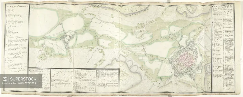
Map of Mons and Saint-Ghislain and environs, ca. 1709, Samuel Du Ry de Champdoré, 1709, Large map of the environs of the towns of Mons (Mons) and Saint-Ghislain with all fortifications and inundations, probably at the time of the siege in 1709. Legends 1-52 and 1-68 on the right, other legends on the left and bottom, all in French. Part of a collection of drawn plans of fortified places in the Netherlands and surrounding countries at the time of the War of the Spanish Succession (part C)., draughtsman: Samuel Du Ry de Champdoré, Netherlands, 1709, paper, h 518 mm × w 1360 mm
SuperStock offers millions of photos, videos, and stock assets to creatives around the world. This image of Map of Mons and Saint-Ghislain and environs, ca. 1709, Samuel Du Ry de Champdoré, 1709, Large map of the environs of the towns of Mons (Mons) and Saint-Ghislain with all fortifications and inundations, probably at the time of the siege in 1709. Legends 1-52 and 1-68 on the right, other legends on the left and bottom, all in French. Part of a collection of drawn plans of fortified places in the Netherlands and surrounding countries at the time of the War of the Spanish Succession (part C)., draughtsman: Samuel Du Ry de Champdoré, Netherlands, 1709, paper, h 518 mm × w 1360 mm by Artokoloro is available for licensing today.
Looking for a license?
Click here, and we'll help you find it! Questions? Just ask!
Click here, and we'll help you find it! Questions? Just ask!
DETAILS
Image Number: 4443-21725795Rights ManagedCredit Line:Artokoloro/SuperStockCollection:Artokoloro Model Release:NoProperty Release:NoResolution:10706×4304