Map of central and eastern North America representing the New France before the French and Indian War (1755-63): French (yellow), Spanish (pink) and English (Green). Explorers Joliet and Marquette, La Salle, and Louis Hennepin established France's claim for extensive territory in central North American in the 17th century. LaSalle named it 'Louisiana' for the King Louis XIV during his exploration of the Great Lakes region of the United States and Canada, the Mississippi River, and the Gulf of Mexico. Cartouche include Hennepin's depictions of Niagara Falls and the American Bison. Map is by German Cartographer, Johann Baptist Homann, (1663-1724) (BSLOC_2020_1_135)

Map of central and eastern North America representing the New France before the French and Indian War (1755-63): French (yellow), Spanish (pink) and English (Green). Explorers Joliet and Marquette, La Salle, and Louis Hennepin established France's claim for extensive territory in central North American in the 17th century. LaSalle named it 'Louisiana' for the King Louis XIV during his exploration of the Great Lakes region of the United States and Canada, the Mississippi River, and the Gulf of Mexico. Cartouche include Hennepin's depictions of Niagara Falls and the American Bison. Map is by German Cartographer, Johann Baptist Homann, (1663-1724)  (BSLOC_2020_1_135)
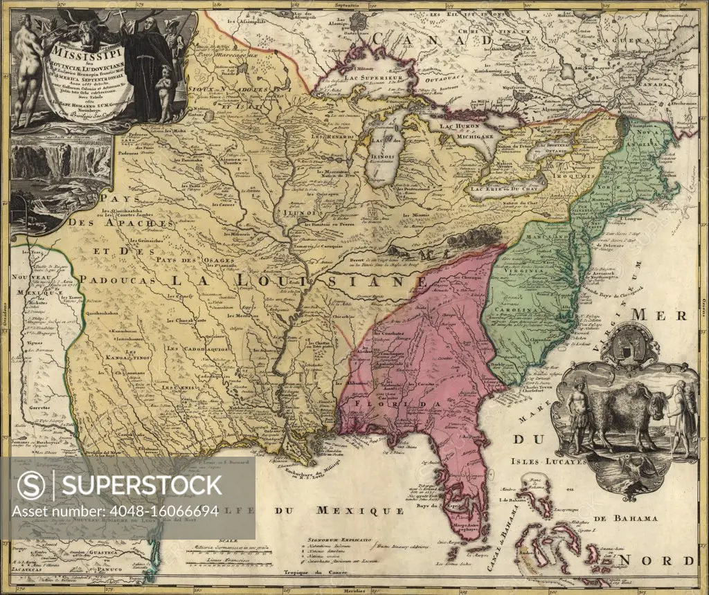
SuperStock offers millions of photos, videos, and stock assets to creatives around the world. This image of Map of central and eastern North America representing the New France before the French and Indian War (1755-63): French (yellow), Spanish (pink) and English (Green). Explorers Joliet and Marquette, La Salle, and Louis Hennepin established France's claim for extensive territory in central North American in the 17th century. LaSalle named it 'Louisiana' for the King Louis XIV during his exploration of the Great Lakes region of the United States and Canada, the Mississippi River, and the Gulf of Mexico. Cartouche include Hennepin's depictions of Niagara Falls and the American Bison. Map is by German Cartographer, Johann Baptist Homann, (1663-1724) (BSLOC_2020_1_135) by Everett Collection is available for licensing today.
$24.99
Editorial Personal Use
Editorial Personal Use. Non-commercial, one-time, personal/home usage, in perpetuity and Worldwide. Personal prints, cards, gifts, or reference for artists. Non-commercial use only, not for resale.
$89.99
Editorial Presentation or Newsletters
Editorial use in a presentation or newsletters. Use in a presentation/talk (eg, Powerpoint and Keynote) or in an editorial newsletter.
$115.00
Editorial Website
Editorial website use in a single website, app, social media, or blog (excludes advertising), worldwide.
$225.00
Editorial Magazines and Books - Interior
Editorial Non-exclusive use inside of a Magazine, Book, or Educational use, both print and digital, in any language. (No advertising, promotion or commercial use of any kind). Worldwide in Perpetuity. DOES NOT INCLUDE COVER USE
  • Download your images from the download tab on this page after purchase.
  • Up to 3 downloads
  • Can be used for 365 days after purchase.
$59.99
RM Personal Print 3 Pack
Save $14.98
$20.00
per download
Looking for a license?
Click here, and we'll help you find it! Questions? Just ask!
DETAILS
Image Number: 4048-16066694Rights ManagedCredit Line:Everett Collection/SuperStockCollection:Model Release:NoProperty Release:NoResolution:3000×2522
|
|
|
|
|
|
|
|
|
|
|
|
|
|
|
|
|
|
|
|
|
|
|
|
|
|
|
|
|
|
|
|
|
|
|
|
|
|
|
|
|
|