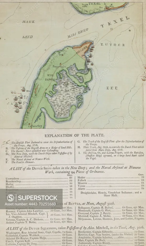
London, Westley, RH, England, On exact Plan of the Capture of the Helder & Port of the Texel 27th of August 1799, Map of the head of North Holland and Texel, captured by the British, 1799, verso - stamped, English map of the head of North Holland with Den Helder and the port of Texel, captured by the English during the invasion on 27 August 1799. Also a squadron of English shovels off the coast at Callantsoog. Below the map the legend AI, a list of the captured Dutch ships in the Nieuwe Diep, a list of the English warships and a list of the Dutch ships captured at Texel on 30 August 1799., print, prent, map, prints, Frederik Muller Historieplaten, height 415 mm, width 255 mm, print maker, printmaker, 1799-09 - 1799-09, paper, papier, etching, etchings, hand colouring, letterpress printing, Publication (Event), Publicatie, publisher
SuperStock offers millions of photos, videos, and stock assets to creatives around the world. This image of London, Westley, RH, England, On exact Plan of the Capture of the Helder & Port of the Texel 27th of August 1799, Map of the head of North Holland and Texel, captured by the British, 1799, verso - stamped, English map of the head of North Holland with Den Helder and the port of Texel, captured by the English during the invasion on 27 August 1799. Also a squadron of English shovels off the coast at Callantsoog. Below the map the legend AI, a list of the captured Dutch ships in the Nieuwe Diep, a list of the English warships and a list of the Dutch ships captured at Texel on 30 August 1799., print, prent, map, prints, Frederik Muller Historieplaten, height 415 mm, width 255 mm, print maker, printmaker, 1799-09 - 1799-09, paper, papier, etching, etchings, hand colouring, letterpress printing, Publication (Event), Publicatie, publisher by Artokoloro is available for licensing today.
Looking for a license?
Click here, and we'll help you find it! Questions? Just ask!
Click here, and we'll help you find it! Questions? Just ask!
DETAILS
Image Number: 4443-73251660Rights ManagedCredit Line:Artokoloro/SuperStockCollection:Artokoloro Model Release:NoProperty Release:NoResolution:3775×6319