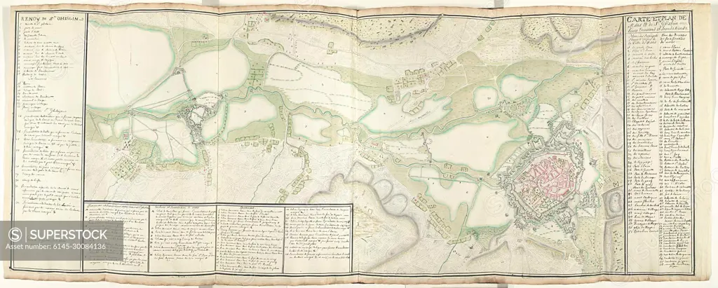
Kaart van Mons in Saint-Ghislain in omgeving, ca. 1709; Map and map of Mons and St. Ghislain with their surroundings and floods.Large map of the surroundings of the cities of Mons (Bergen) and Saint-Ghislain with all reinforcements and inundations, probably at the time of the topping in 1709. On the right the legendas 1-52 and 1-68, left and at the bottom of the other legendas, everything in French. Part of a collection of signed plans of reinforced places in the Netherlands and surrounding countries at the time of the Spanish Succession War (part c).
SuperStock offers millions of photos, videos, and stock assets to creatives around the world. This image of Kaart van Mons in Saint-Ghislain in omgeving, ca. 1709; Map and map of Mons and St. Ghislain with their surroundings and floods.Large map of the surroundings of the cities of Mons (Bergen) and Saint-Ghislain with all reinforcements and inundations, probably at the time of the topping in 1709. On the right the legendas 1-52 and 1-68, left and at the bottom of the other legendas, everything in French. Part of a collection of signed plans of reinforced places in the Netherlands and surrounding countries at the time of the Spanish Succession War (part c). by Piemags/PL Photography Limited is available for licensing today.
Looking for a license?
Click here, and we'll help you find it! Questions? Just ask!
Click here, and we'll help you find it! Questions? Just ask!
DETAILS
Image Number: 6145-30084136Royalty FreeCredit Line:Piemags/PL Photography Limited/SuperStockCollection:PL Photography Limited Contributor:Piemags Model Release:NoProperty Release:NoResolution:2500×1005