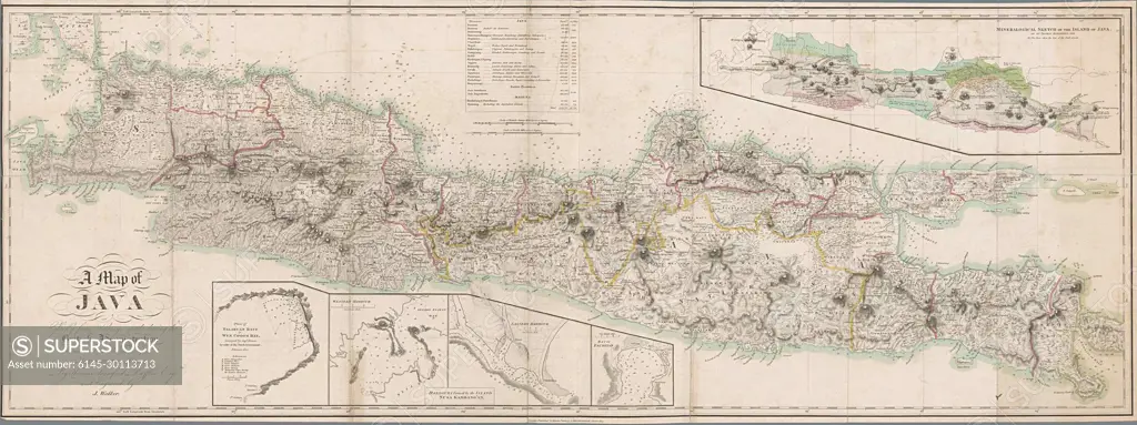
Kaart van Java met vijf bijkaartjes.Map of Java, the borders and coasts. 5 CONDRESS: L.O. Until, .o. Plan by Palabuan Ratu or Coops Coops Bay by Capt. Bare, the western and also the eastern harbor formed by the island of Nusa Kambang'an, the bay of Pachitan, R.B.: Mineralogical map by Thomas Horsfield, 1812. m.b. Is the bowl in British and Dutch miles. Inscription; L.O.: a Map of / Java / Chiefly From Surveys Made During The / British Administration / Constructed in illustration of an / account or Java.
SuperStock offers millions of photos, videos, and stock assets to creatives around the world. This image of Kaart van Java met vijf bijkaartjes.Map of Java, the borders and coasts. 5 CONDRESS: L.O. Until, .o. Plan by Palabuan Ratu or Coops Coops Bay by Capt. Bare, the western and also the eastern harbor formed by the island of Nusa Kambang'an, the bay of Pachitan, R.B.: Mineralogical map by Thomas Horsfield, 1812. m.b. Is the bowl in British and Dutch miles. Inscription; L.O.: a Map of / Java / Chiefly From Surveys Made During The / British Administration / Constructed in illustration of an / account or Java. by Piemags/PL Photography Limited is available for licensing today.
Looking for a license?
Click here, and we'll help you find it! Questions? Just ask!
Click here, and we'll help you find it! Questions? Just ask!
DETAILS
Image Number: 6145-30113713Royalty FreeCredit Line:Piemags/PL Photography Limited/SuperStockCollection:PL Photography Limited Contributor:Piemags Model Release:NoProperty Release:NoResolution:2500×937