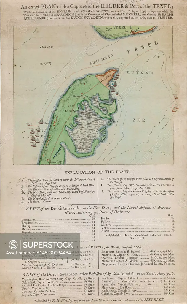
Kaart van de kop van Noord-Holland en Texel, veroverd door de Britten, 1799; Aan exact Plan of the Capture of the Helder & Port of the Texel (...) 27th of August 1799.English map of the head of Noord-Holland with Den Helder and the Harbor Texel, conquered by the English by the raid on August 27, 1799. Also a squadron English scoop off the coast at Callantsoog. Under the map The legend A-I, a list of the conquered Dutch ships in the new deep, a list of the English warships and a list of Dutch ships conquered at Texel on August 30, 1799.
SuperStock offers millions of photos, videos, and stock assets to creatives around the world. This image of Kaart van de kop van Noord-Holland en Texel, veroverd door de Britten, 1799; Aan exact Plan of the Capture of the Helder & Port of the Texel (...) 27th of August 1799.English map of the head of Noord-Holland with Den Helder and the Harbor Texel, conquered by the English by the raid on August 27, 1799. Also a squadron English scoop off the coast at Callantsoog. Under the map The legend A-I, a list of the conquered Dutch ships in the new deep, a list of the English warships and a list of Dutch ships conquered at Texel on August 30, 1799. by Piemags/PL Photography Limited is available for licensing today.
Looking for a license?
Click here, and we'll help you find it! Questions? Just ask!
Click here, and we'll help you find it! Questions? Just ask!
DETAILS
Image Number: 6145-30094484Royalty FreeCredit Line:Piemags/PL Photography Limited/SuperStockCollection:PL Photography Limited Contributor:Piemags Model Release:NoProperty Release:NoResolution:1541×2500