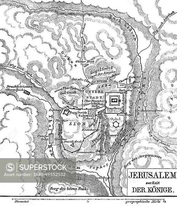
Jerusalem in the time of the kings, map, rivers, Kidron, valley, Ben Hinnom, mountains, Temple Mount, Lower City, Hill Gareb, Zion, David's Tomb, Castle of David, Solomon's Palace, Akba, Lower Pond, Upper Pond, Jericho Way, Dragon Well, scale, geographical mile, hatchings, Bible, Old Testament, Second Book of Samuelis, chapters, historical illustration c. 1850, Middle East
SuperStock offers millions of photos, videos, and stock assets to creatives around the world. This image of Jerusalem in the time of the kings, map, rivers, Kidron, valley, Ben Hinnom, mountains, Temple Mount, Lower City, Hill Gareb, Zion, David's Tomb, Castle of David, Solomon's Palace, Akba, Lower Pond, Upper Pond, Jericho Way, Dragon Well, scale, geographical mile, hatchings, Bible, Old Testament, Second Book of Samuelis, chapters, historical illustration c. 1850, Middle East by Wolfgang Diederich/imageBROKER is available for licensing today.
DETAILS
Image Number: 1848-49552532Rights ManagedCredit Line:Wolfgang Diederich/imageBROKER/SuperStockCollection:imageBROKER Contributor:Wolfgang Diederich Model Release:NoProperty Release:NoResolution:4257×4954