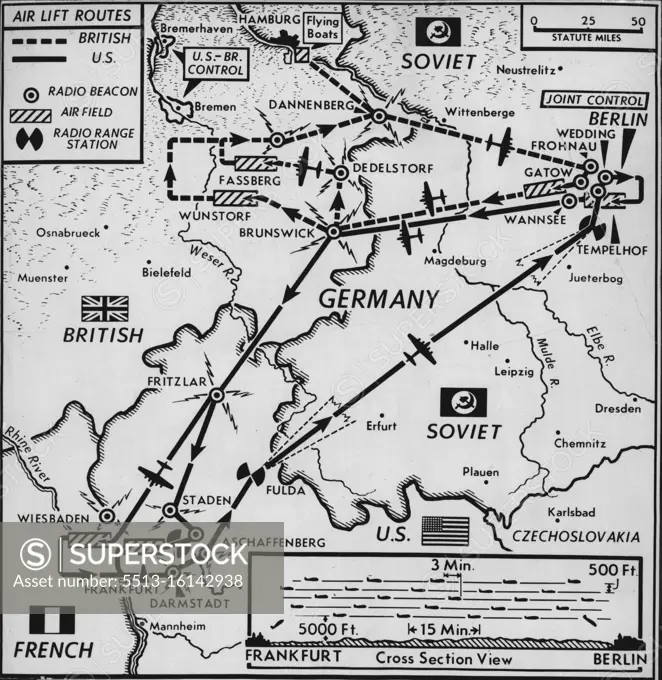
How The Airlift Works In Berlin -- This map shows how U.S. and British air forces feed land-blockaded Berlin. Most U.S. planes use the southern corridor into Berlin. This runs almost on a bee-line from Frankfurt. Into it feed C-54 ransports from Frankfurt's Rhein-Main airbase and C-47s from nearby Wiesbaden. All these planes land at Tempelhof, U.S. operated airbase in Berlin. All British planes and about 40 U.S. C-47s use Northern corridor to Berlin, running southeast from Hamburg area and landing at British-Operated Gatow Airfield in Berlin. British zone takeoff fields are at Fassberg and Wunstorf with flying boats basing at Hamburg and landing on Berling's Havel Lake. October 13, 1948. (Photo by Associated Press Photo0.
SuperStock offers millions of photos, videos, and stock assets to creatives around the world. This image of Explore the Historical Berlin Airlift Route Map: Allied and Soviet Zones During the Cold War Era by Associated Press Photo/Sydney Morning Herald is available for licensing today.
DETAILS
Image Number: 5513-16142938Rights ManagedCredit Line:Associated Press Photo/Sydney Morning Herald/SuperStockCollection:Sydney Morning Herald Contributor:Associated Press Photo / Sydney Morning Herald Model Release:NoProperty Release:NoResolution:2283×2342