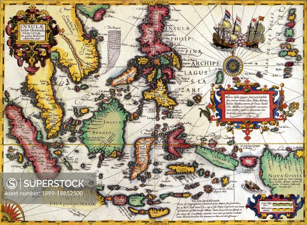
A highly decorative map of the East Indies from the Mercator-Hondius Atlas. It extends from the Philippines to Timor and Sumatra to New Guinea, detailing the Spice Islands, a region of great importance to seventeenth century Europe, but one about which little was known at the time. Hondius based his map on portolan charts by Portuguese cartographer Bartolomeu Lasso. Of particular note is the comment Huc Franciscus Dra. Appulit, which appears by the unknown southern coast of Java, representing Drake's landing during his circumnavigation of the globe in 1577-80. Of considerable contemporary relevance, the map also shows a highly stylised diagram of the Spratly Islands and perhaps the Paracels in the South China Sea, indicating ownership lying with Vietnam and Indochina, not - as vociferously claimed by the People's Republic - with China. This map follows very shortly the extension of Dutch control over the islands. In 1602 the Dutch East India Company was formed, and within a couple dec
SuperStock offers millions of photos, videos, and stock assets to creatives around the world. This image of A highly decorative map of the East Indies from the Mercator-Hondius Atlas. It extends from the Philippines to Timor and Sumatra to New Guinea, detailing the Spice Islands, a region of great importance to seventeenth century Europe, but one about which little was known at the time. Hondius based his map on portolan charts by Portuguese cartographer Bartolomeu Lasso. Of particular note is the comment Huc Franciscus Dra. Appulit, which appears by the unknown southern coast of Java, representing Drake's landing during his circumnavigation of the globe in 1577-80. Of considerable contemporary relevance, the map also shows a highly stylised diagram of the Spratly Islands and perhaps the Paracels in the South China Sea, indicating ownership lying with Vietnam and Indochina, not - as vociferously claimed by the People's Republic - with China. This map follows very shortly the extension of Dutch control over the islands. In 1602 the Dutch East India Company was formed, and within a couple dec by Pictures from History/Universal Images is available for licensing today.
Looking for a license?
Click here, and we'll help you find it! Questions? Just ask!
Click here, and we'll help you find it! Questions? Just ask!
DETAILS
Image Number: 1899-18852500Rights ManagedCredit Line:Pictures from History/Universal Images/SuperStockCollection: