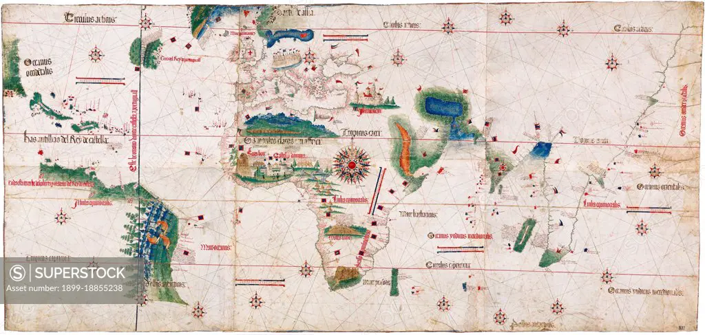
The Cantino planisphere (or Cantino World Map) is the earliest surviving map showing Portuguese geographic discoveries in the east and west. It is named after Alberto Cantino, an agent for the Duke of Ferrara, who successfully smuggled it from Portugal to Italy in 1502. The map is particularly notable for portraying a fragmentary record of the Brazilian coast, discovered in 1500 by the Portuguese explorer Pedro Álvares Cabral, and for depicting the African coast of the Atlantic and Indian Oceans with a remarkable accuracy and detail. It was valuable at the beginning of the sixteenth century because it showed detailed and up-to-date strategic information in a time when geographic knowledge of the world was growing at a fast pace. It is important in our days because it contains unique historical information about the maritime exploration and the evolution of nautical cartography in a particularly interesting period. The Cantino planisphere is the earliest extant nautical chart where plac
SuperStock offers millions of photos, videos, and stock assets to creatives around the world. This image of The Cantino planisphere (or Cantino World Map) is the earliest surviving map showing Portuguese geographic discoveries in the east and west. It is named after Alberto Cantino, an agent for the Duke of Ferrara, who successfully smuggled it from Portugal to Italy in 1502. The map is particularly notable for portraying a fragmentary record of the Brazilian coast, discovered in 1500 by the Portuguese explorer Pedro Álvares Cabral, and for depicting the African coast of the Atlantic and Indian Oceans with a remarkable accuracy and detail. It was valuable at the beginning of the sixteenth century because it showed detailed and up-to-date strategic information in a time when geographic knowledge of the world was growing at a fast pace. It is important in our days because it contains unique historical information about the maritime exploration and the evolution of nautical cartography in a particularly interesting period. The Cantino planisphere is the earliest extant nautical chart where plac by Pictures From History/Universal Images is available for licensing today.
DETAILS
Image Number: 1899-18855238Rights ManagedCredit Line:Pictures From History/Universal Images/SuperStockCollection: